
Class 10 Geography Question and Answer: India – Geographical Position and Physical Features
Looking for SSLC Class 10 Social Science Studies textbook answers? You can download Chapter 1: India – Geographical Position and Physical Features Questions and Answers PDF, Notes, and Additional Q&A here. SSLC Social Science solutions follow the Karnataka State Board Syllabus, making it easier for students to revise and score higher in exams.
Karnataka SSLC Social Geography Textbook Answers—Reflections Chapter 1
India – Geographical Position and Physical Features Questions and Answers, Notes, and Additional Q&A
Class 10 Geography Chapter 1
India – Geographical Position and Physical Features
Scroll Down to Download India – Geographical Position and Physical Features PDF
I. Fill in the blanks with suitable words.
- The name ‘India’ is derived from the river Indus.
- The total area of India is 32,87,263 kms.
- In the central part of India 23°30′ North latitude (Tropic of Cancer) passes.
- The coastline of India with major land mass is 6,100 kms.
- The Indian physiography has been divided into four major parts.
- Greater Himalaya is also called Himadri.
- The highest mountain peak in the world is Mount Everest.
- The North Indian plain is made up of alluvial
- The Western Ghats in Karnataka are also called Sahyadri.
II. Answer the following questions in brief.
Question 1.
In which part of the Asian continent is India situated?
Answer:
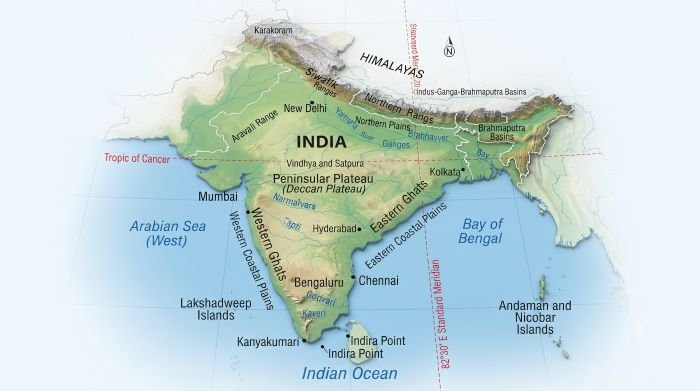
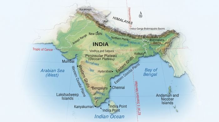
India is situated in South Asia.
Question 2.
In which hemisphere of the earth is India located?
Answer:
India is located in the Northern and Eastern Hemispheres.
Question 3.
Which is the southern tip of mainland of India?
Answer:
Kanyakumari is the southern tip of mainland India.
Question 4.
Which is the southernmost point of India?
Answer:
Indira Point in the Great Nicobar Island is the southernmost point of India.
Question 5.
What is the other name for the foothills of the Himalayas?
Answer:
The foothills of the Himalayas are called the Siwalik Range.
Question 6.
Which is the recently-formed landmass in India?
Answer:
The Siwalik Range is the recently formed landmass of the Himalayas.
Question 7.
What are the advantages of the Himalayas?
Answer:
The Himalayan mountains have influenced the life of Indians to a great extent.
- The Himalayas protect India by obstructing the cold winds from the North Asian regions.
- They are the birthplace of many rivers.
- They help in the generation of hydroelectric power.
- They are home to many types of plants and animals.
- They are a great treasure-house of minerals.
- They are important for tourism and religious centres.
Question 8.
Explain the extent of the Peninsular Plateau.
Answer:
The Peninsular Plateau is the largest of all the physiographic divisions of India. The Peninsular Plateau stretches from the south of the Sutlej-Ganga Plains up to the Indian Ocean in the south. Its total area is around 16 lakh sq. km. It stretches from the Aravalli Mountains in the north to Kanyakumari in the south. It extends approximately 1,400 km from the Western Ghats in the west to the Rajmahal Hills of Jharkhand in the east.
Question 9.
Write about the Shivalik Range.
Answer:
The Siwalik Range is the southernmost range of the Himalayas. These hills are the most recently formed and are located in the southern part of the Himalayas. They have a lower height and are also called the Foothills of the Himalayas. These hills have narrow strips of plains or valleys called “Duns”. Examples of Duns are Dehradun, Kota, Patli, Chaukhamba, Udhampur and Kotli. The Siwalik Range is about 600–1,500 metres above sea level.
Question 10.
“The Northern Plains are called deposited plains.” Why?
Answer:
The Northern Plains are also called the Sutlej-Ganga Plains. They extend from the Indus plains in the west to the Brahmaputra valley in the east. These plains are almost flat and have very little variation in height. The entire plain is formed by the deposition of alluvial soil brought by the rivers originating in the Himalayas. Therefore, the Northern Plains are called “deposited plains.”
Question 11.
Mention the differences between Western and Eastern Ghats.
Answer:
Western Ghats | Eastern Ghats |
They are located to the west of the Deccan Plateau. | They are located to the east of the Deccan Plateau. |
They are continuous mountain ranges. | They are discontinuous mountain ranges. |
They are generally higher than the Eastern Ghats. | They are generally lower than the Western Ghats. |
Anaimudi (2,695 m) is the highest peak in South India. | Arma Konda and Mahendragiri are the highest peaks. |
In Maharashtra and Karnataka, they are called Sahyadri. | They are separated by river valleys at several places. |
They lie between the Arabian Sea and the Deccan Plateau. | They lie between the Bay of Bengal and the Deccan Plateau. |
Additional Questions and Answers
Short Answer Questions
Question 1.
Why is India called a sub-continent?
Answer:
India is called a sub-continent because it has great diversity in physical features, climate, natural vegetation and people.
Question 2.
How did India get its name?
Answer:
The name India is derived from the River Indus.
Question 3.
Why is India called Bharat?
Answer:
India is called Bharat after the ancient Indian king Bharata.
Question 4.
What is the total area of India?
Answer:
The total area of India is 32,87,263 sq. km.
Question 5.
What percentage of the world’s total area is occupied by India?
Answer:
India occupies about 2.4% of the world’s total area.
Question 6.
What is the latitudinal extent of mainland India?
Answer:
The mainland of India extends from 8°4′ N to 37°6′ N latitudes.
Question 7.
What is the longitudinal extent of India?
Answer:
India extends from 68°7′ E to 97°25′ E longitudes.
Question 8.
Which longitude is the basis of Indian Standard Time?
Answer:
82°30′ E longitude is the basis of Indian Standard Time.
Question 9.
Through which place does the Standard Meridian of India pass?
Answer:
The Standard Meridian of India passes through Prayagraj.
Question 10.
What is the southernmost point of India?
Answer:
Indira Point in the Great Nicobar Island is the southernmost point of India.
Question 11.
What is the southern tip of mainland India?
Answer:
Kanyakumari is the southern tip of mainland India.
Question 12.
Name the three main ranges of the Himalayas.
Answer:
The three main ranges are:
- Siwalik Range
- Himachal Range
- Greater Himalayas (Himadri)
Question 13.
What are Duns?
Answer:
Duns are narrow strips of plains or valleys found between the Siwalik hills.
Question 14.
What is Himadri?
Answer:
The Greater Himalayas are also called Himadri. They contain the highest peaks of the Himalayas and remain covered with snow.
Question 15.
What is the Trans-Himalayas?
The range of fold mountains lying to the north of the Greater Himalayas is called the Trans-Himalayas. It includes the Karakoram and Kailash ranges.
Multiple Choice Questions
1. The name India is derived from:
A) Ganga
B) Yamuna
C) Indus
D) Brahmaputra
Answer:
C) Indus
2. India is situated in:
A) North Asia
B) South Asia
C) West Asia
D) Central Asia
Answer:
B) South Asia
3. India is located in the:
A) Southern and Western Hemispheres
B) Northern and Eastern Hemispheres
C) Northern and Western Hemispheres
D) Southern and Eastern Hemispheres
Answer:
B) Northern and Eastern Hemispheres
4. The total area of India is:
A) 22,87,263 sq. km
B) 32,87,263 sq. km
C) 42,87,263 sq. km
D) 12,87,263 sq. km
Answer:
B) 32,87,263 sq. km
5. India is the ______ largest country in the world by area.
A) Fifth
B) Sixth
C) Seventh
D) Eighth
Answer:
C) Seventh
6. The Tropic of Cancer passes through:
A) Northern India
B) Central India
C) Southern India
D) Western India only
Answer:
B) Central India
7. The Standard Meridian of India is:
A) 68°7′ E
B) 97°25′ E
C) 82°30′ E
D) 23°30′ E
Answer:
C) 82°30′ E
8. The southernmost point of India is:
A) Kanyakumari
B) Indira Point
C) Chennai
D) Kochi
Answer:
B) Indira Point
9. The boundary between India and Pakistan is called:
A) McMahon Line
B) Durand Line
C) Radcliffe Line
D) Line of Control
Answer:
C) Radcliffe Line
10. The boundary between India and China is called:
A) Radcliffe Line
B) McMahon Line
C) Durand Line
D) 82°30′ Line
Answer:
B) McMahon Line
11. The southernmost range of the Himalayas is:
A) Himadri
B) Himachal
C) Siwalik
D) Karakoram
Answer:
C) Siwalik
12. Greater Himalayas are also known as:
A) Himachal
B) Himadri
C) Siwalik
D) Sahyadri
Answer:
B) Himadri
13. The valleys found in the Siwalik Range are called:
A) Doabs
B) Duns
C) Deltas
D) Lagoons
Answer:
B) Duns
14. Mount Everest is:
A) 6,611 m high
B) 7,848 m high
C) 8,848 m high
D) 9,848 m high
Answer:
C) 8,848 m high
15. The Northern Plains are mainly formed by:
A) Lava
B) Alluvial deposits
C) Sand dunes
D) Volcanic rocks
Answer:
B) Alluvial deposits
16. The older alluvial soil is called:
A) Khadar
B) Bhabar
C) Bhangar
D) Regur
Answer:
C) Bhangar
17. The newer alluvial soil is called:
A) Khadar
B) Bhangar
C) Bhabar
D) Laterite
Answer:
A) Khadar
18. The Peninsular Plateau is:
A) The youngest physiographic division
B) The most ancient physiographic division
C) A coastal plain
D) A Himalayan range
Answer:
B) The most ancient physiographic division
19. The Western Ghats are also called ______ in Karnataka and Maharashtra.
A) Aravalli
B) Sahyadri
C) Himadri
D) Mahabharat
Answer:
B) Sahyadri
20. The highest peak in South India is:
A) Mahendragiri
B) Anaimudi
C) Arma Konda
D) Nanda Devi
Answer:
B) Anaimudi
21. The Western Ghats are generally:
A) Discontinuous
B) Continuous
C) Very low
D) Completely flat
Answer:
B) Continuous
22. The Eastern Ghats are:
A) Continuous and very high
B) Discontinuous and lower
C) Snow-covered
D) Part of the Himalayas
Answer:
B) Discontinuous and lower
23. Chilka Lake is located in:
A) Kerala
B) Karnataka
C) Odisha
D) Gujarat
Answer:
C) Odisha
24. Lakshadweep Islands are mainly:
A) Volcanic islands
B) Coral islands
C) River islands
D) Mountain islands
Answer:
B) Coral islands
25. Indira Point is located in:
A) Andaman Island
B) Great Nicobar Island
C) Lakshadweep
D) Sri Lanka
Answer:
B) Great Nicobar Island