1st PUC Geography Chapter 9 Q&A – India
Looking for 1st PUC Geography Chapter 9 Q&A? Here you can download the complete Chapter 9: Physiography Questions and Answers, notes, and summary. These 1st PUC Geography solutions follow the Karnataka State Board syllabus, making it easier for students to revise and score higher in exams.
1st PUC Geography Chapter 9
Physiography
Scroll Down to Download Physiography PDF
I. One Mark Questions – 1st PUC Geography Chapter 9 Q&A
Question 1.
What is the other name to the Himalayas?
Answer:
Abode of Snow.
Question 2.
Which mountain range is called ‘backbone of Asia’?
Answer:
The Karakoram Range.
Question 3.
Name the longest and the largest glacier of India.
Answer:
Siachen Glacier.
Question 4.
What is the other name to Outer Himalayas?
Answer:
Siwaliks.
Question 5.
Name the largest doon of India.
Answer:
Dehradun Doon.
Question 6.
In which regional Himalayas is Jelep-la pass found?
Answer:
Central or Sikkim Himalayas.
Question 7.
What is Terai plain?
Answer:
A marshy plain found south of the Bhabar region where streams reappear.
Question 8.
Mention the highest peak of the Peninsular Plateau.
Answer:
Anai Mudi.
Question 9.
Which region of India is called ‘Ruhr of India’?
Answer:
Chotanagpur Plateau.
Question 10.
Where do Western Ghats and Eastern Ghats meet?
Answer:
At the Nilgiri Hills.
Question 11.
Name the longest coastal plains of India.
Answer:
The East Coastal Plains.
Question 12.
Why are the Himalayan rivers perennial?
Answer:
Because they are fed by glaciers and rainfall throughout the year.
Question 13.
From which mountain pass does the river Sutlej enter India?
Answer:
Shipki-la Pass.
Question 14.
Which is the longest and the largest tributary of the Ganga?
Answer:
The Yamuna.
Question 15.
Name the largest and the longest river of South India.
Answer:
The Godavari.
II. Two Mark Questions – 1st PUC Geography Chapter 9 Q&A
Question 1.
Mention any two ranges of Trans-Himalayas.
Answer:
The Trans-Himalayas consist of mountain ranges such as the Karakoram Range and the Ladakh Range. These ranges run parallel to the Great Himalayas in Jammu and Kashmir.
Question 2.
Name any two hill stations of the Himalayas.
Answer:
Shimla and Mussoorie are two important hill stations of the Himalayas. They are popular for their cool climate and scenic beauty.
Question 3.
Distinguish between Bhangar and Khadar plains.
Answer:
Bhangar plains are formed by older alluvium and lie above the flood level of rivers. Khadar plains are formed by newer alluvium and are renewed every year by river floods, making them more fertile.
Question 4.
Name any two ghats of the Western Ghats.
Answer:
Thal Ghat and Bhor Ghat are two important passes of the Western Ghats. They connect Mumbai with the interior regions of Maharashtra.
Question 5.
Which coastal plains are found in Karnataka and Tamil Nadu?
Answer:
The Karnataka Coast forms part of the West Coastal Plains. The Coromandel Coast is found along the coast of Tamil Nadu on the East Coastal Plains.
Question 6.
State the difference between Lakshadweep and Andaman and Nicobar Islands.
Answer:
Lakshadweep Islands are coral in origin and are located in the Arabian Sea. Andaman and Nicobar Islands are tectonic and volcanic in origin and lie in the Bay of Bengal.
Question 7.
Name any four tributaries of river Indus.
Answer:
The important tributaries of the Indus are Jhelum, Chenab, Ravi, and Beas.
Question 8.
Mention any four west-flowing rivers of Peninsular India.
Answer:
Narmada, Tapi, Sharavati, and Periyar are important west-flowing rivers of Peninsular India. These rivers flow into the Arabian Sea.
Question 9.
What are the salient features of river regime?
Answer:
River regime refers to the seasonal variation in the flow of a river. It depends on rainfall, temperature, and the nature of the drainage basin.
Question 10.
What is the necessity of Inter-linking of Rivers?
Answer:
Inter-linking of rivers is necessary to reduce floods and droughts by transferring surplus water to water-scarce regions. It also helps in better utilization of water resources for irrigation and power generation.
III. FiveMark Questions – 1st PUC Geography Chapter 9 Q&A
Question 1.
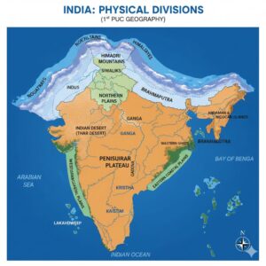
Name the important physical divisions of India. Explain the Himalayas.
Answer:
India is characterized by great diversity in its physical features. On the basis of physiography, the country is divided into four major physical divisions. They are:
- The Northern Mountains
- The Northern Plains
- The Peninsular Plateau
- The Coastal Plains and Islands
The Himalayas:
The Himalayas are the loftiest and snow-covered mountains in the world. The region occupied by the Himalayas was earlier a part of the Tethys Sea. They were formed due to tectonic forces caused by the collision of the Gondwana and Angara land masses. The Himalayas lie to the north of the Indus, Ganga and Brahmaputra plains. Their slopes are gentle towards the north and steep towards the south.
The Himalayas are characterized by high relief, snow-covered peaks, complex geological structures, parallel mountain ranges separated by deep valleys, and rich temperate vegetation. Based on altitude and latitude, the Himalayas are divided into three parallel ranges:
- The Great Himalayas or Himadri
- The Lesser Himalayas or Himachal
- The Outer Himalayas or Siwaliks
- a) The Great Himalayas or Himadri:
These are the innermost, loftiest and most continuous mountain ranges. The average height is about 6200 m, and the width varies between 120 and 190 km. Important peaks include Kanchenjunga (8598 m), Nanga Parbat (8126 m), Nanda Devi, Badrinath, Kamet, and Trishul. - b) The Lesser Himalayas or Himachal:
These ranges lie between the Great Himalayas in the north and the Siwaliks in the south. Their average height ranges from 1500 to 4500 m, and the width is about 60–80 km. These ranges are rugged and highly dissected by rivers. Important ranges include Pir Panjal, Dhauladhar, and Nag Tibba. Famous hill stations such as Shimla, Mussoorie, Ranikhet, Nainital, Almora, Chakrata, and Darjeeling are found here. Kullu, Kangra, and Spiti are important valleys. - c) The Outer Himalayas or Siwaliks:
These are the outermost ranges located south of the Lesser Himalayas. They extend from Jammu and Kashmir in the northwest to Arunachal Pradesh in the east. The average height ranges between 600 and 1500 m, and the width varies from 15 to 50 km. The Siwaliks are formed from sediments brought down by rivers from the Greater and Lesser Himalayas. Flat-floored valleys found between the Siwaliks and the Lesser Himalayas are called Doons.
Question 2.
Briefly explain the Regional Himalayas.
Answer:
The Himalayas are also classified into regional or longitudinal divisions based on their east–west extent. They are divided into the following five regions:
- The Kashmir Himalayas
- The Himachal Himalayas
- The Kumaun Himalayas
- The Central or Sikkim Himalayas
- The Eastern Himalayas
- a) The Kashmir Himalayas:
The Kashmir Himalayas extend over Jammu and Kashmir. Important parallel ranges found here are the Karakoram, Ladakh, Zaskar and Pir Panjal ranges. This region is characterized by high snow-covered peaks, deep valleys, numerous glaciers, and important mountain passes. The north-eastern part is a cold desert region lying between the Great Himalayas and the Karakoram range. A special feature of this region is the Karewas. Important mountain passes include Banihal, Zoji-la, Chang-la and Khardung-la. - b) The Himachal Himalayas:
The Himachal Himalayas are found in Himachal Pradesh and parts of Punjab and include all the three Himalayan ranges. Famous valleys such as Kullu, Kangra, Lahaul and Spiti are located here and are known for their scenic beauty and orchards. Important mountain passes include Shipki-la, Rohtang Pass and Bara-lacha-la. Hill stations like Shimla, Kullu-Manali, Dalhousie and Chamba are also located in this region. - c) The Kumaun Himalayas:
This section extends from the Sutlej to the Kali river valleys and covers a distance of about 320 km. It is famous for several pilgrimage centres such as Badrinath and Gangotri. Peaks like Nanda Devi are also located in this region. - d) The Central or Sikkim Himalayas:
This section extends from the Kali to the Tista river and is also known as the Nepal Himalayas. It includes the highest peaks of the Himalayas, including Mount Everest and Kanchenjunga. For detailed study, this region is divided into the Sikkim, Darjeeling and Bhutan Himalayas. Important passes like Nathu-la and Jelep-la are found here. - e) The Eastern Himalayas:
The Eastern Himalayas extend from the Tista river to the Brahmaputra valley, covering parts of Assam and Arunachal Pradesh. This region includes hill ranges such as the Naga, Patkai Bum and Lushai Hills. The region receives heavy rainfall and is well known for tea cultivation and dense forests.
Question 3.
Describe the significance of Northern Plains.
Answer:
The Northern Plains play a very significant role in the economic, social, and cultural life of India.
- The Northern Plains support a high concentration of population, nearly 45% of India’s population lives in this region.
- The plains have fertile alluvial soil, uniform relief, and perennial rivers, making them highly suitable for agriculture.
- They are ideal for the development of agro-based industries and urbanization.
- The flat terrain has encouraged the growth of transport and communication networks.
- Rivers flowing through the plains facilitate inland water transportation.
- The region has rich underground water resources, useful for irrigation and domestic purposes.
- The Northern Plains have great historical, cultural, and traditional importance as many ancient civilizations developed here.
- They also possess immense social, religious, and political significance.
Question 4.
Peninsular Plateau is the largest physical division of India. Explain its features.
Answer:
The Peninsular Plateau is the largest and the oldest physiographic division of India. It lies to the south of the Northern Plains and covers an area of about 16 lakh sq km. The average elevation of the plateau varies between 600 and 900 metres. It is roughly triangular in shape, with a broad base in the north and a narrow apex in the south, and is tilted towards the south-east.
The Peninsular Plateau is bounded by the Aravalli Range in the north-west, Bundelkhand Plateau in the north, Rajmahal Hills in the north-east, Western Ghats in the west, and Eastern Ghats in the east. The highest peak of the Peninsular Plateau is Anamudi (2695 m) located in the Anamalai Hills of Kerala.
On the basis of relief, the Peninsular Plateau is divided into two major divisions:
- The Central Highlands
The Central Highlands lie to the north of the Narmada River and are slightly tilted towards the north. This region includes the Aravalli Range, Malwa Plateau, Vindhya Range, Bundelkhand Plateau, Baghelkhand Plateau, Chotanagpur Plateau, and Rajmahal Hills.
The Aravalli Range runs from north-east to south-west for about 890 km from Delhi to Gujarat. It is one of the oldest fold mountain systems in the world. Guru Shikhar (1722 m) is its highest peak. The Aravallis are composed of quartzites, gneisses, and schists and separate the Rajasthan desert from the fertile plains.
Important rivers such as the Luni, Sabarmati, and Mahi originate from the Aravalli Range.
The Malwa Plateau lies between the Aravallis in the north and the Vindhya Range in the south. It has two drainage systems:
- Narmada and Mahi flowing towards the Arabian Sea
- Chambal, Sind, Betwa, and Ken flowing towards the Bay of Bengal
The Vindhya Range extends in an east–west direction for about 1050 km. The Kaimur Hills lie in the eastern part of the Vindhyas, and the Maikala Range connects the Vindhya and Satpura ranges.
- The Deccan Plateau
The Deccan Plateau is a triangular plateau lying to the south of the river Tapi (Tapti). It is formed of basaltic lava flows known as the Deccan Trap, produced by fissure volcanic activity. This region is considered a lava shield.
The Deccan Plateau covers parts of Maharashtra, Karnataka, Andhra Pradesh, Telangana, Chhattisgarh, Odisha, and Tamil Nadu.
Eastern Ghats
The Eastern Ghats form the eastern boundary of the Deccan Plateau. They are discontinuous ranges, separated by river valleys. They extend for about 800 km from the Mahanadi valley in the north to the Nilgiri Hills in the south, with an average height of around 600 m.
Important hills include Nallamala, Kollimalai, B.R. Hills, and M.M. Hills.
Important peaks are Arma Konda (the highest peak), Singaraju, Nimalgiri, and Mahendragiri.
This region is rich in iron ore, manganese, limestone, coal, and mica.
Western Ghats
The Western Ghats, also known as the Sahyadris, are a continuous mountain range running parallel to the west coast for about 1600 km. They extend from Gujarat in the north to Kerala in the south and meet the Eastern Ghats at the Nilgiri Hills.
The Western Ghats form the watershed of the Peninsular rivers. Major rivers like the Godavari, Krishna, Kaveri, Sharavati, and Periyar originate here. This region is rich in dense evergreen forests, biodiversity, and is an important source of hydro-electric power.
Question 5.
Briefly explain the Coastal plains of India.
Answer:
The Coastal Plains of India extend along the entire coastline of the country, lying between the coastal line and the Peninsular Plateau. India has a coastline of about 6100 km, extending from Gujarat in the west to West Bengal in the east. The average width of the coastal plains ranges from 10 to 25 km. The Coastal Plains are divided into two major divisions:
- The West Coastal Plains
- The East Coastal Plains
- The West Coastal Plains
The West Coastal Plains extend between the Arabian Sea and the Western Ghats. They are narrower than the East Coastal Plains and stretch for about 1400 km, with a width varying from 10 to 80 km, from the Rann of Kachchh to Kanyakumari. The West Coastal Plains are further divided into four coastal regions:
- a) Gujarat Coast:
It includes the Rann of Kachchh and the Gulf of Khambhat (Cambay). This coast is formed by the alluvial deposits of rivers like Sabarmati, Mahi, Luni, and other small streams. Gujarat has the longest coastline in India. Kandla and Okha are important seaports, and Alang is the largest ship-breaking centre in India. This region produces the highest amount of salt in the country. - b) Konkan Coast:
The Konkan Coast lies south of the Gujarat Coast and is characterized by an irregular and indented coastline, providing suitable sites for natural harbours. Important ports include Mumbai, Jawaharlal Nehru Port (Nhava Sheva), Marmagao, Karwar, and New Mangalore. This coast experiences maximum coastal erosion and is rich in petroleum and natural gas.
The Karnataka Coast forms a part of the Konkan Coast. - c) Karnataka Coast:
It extends from Karwar in the north to Mangalore in the south and is the narrowest part of the West Coastal Plains. Karwar and New Mangalore are important ports. The Sea Bird Naval Base near Karwar is one of the largest naval bases in India. - d) Malabar Coast:
The Malabar Coast extends from Mangalore to Kanyakumari. Sand dunes, lagoons, and backwaters are the important features of this coast. Cochin (Kochi) is the largest seaport on this coast. The backwaters of Kerala facilitate inland navigation and promote tourism. This coast receives the first South-West monsoon rainfall in India. - The East Coastal Plains
The East Coastal Plains lie between the Eastern Ghats and the Bay of Bengal, extending from the Hooghly delta in the north to Kanyakumari in the south. Compared to the West Coastal Plains, they are broader and more continuous.
- a) Utkal Coast:
The Utkal Coast is located in Odisha and extends for about 400 km, from the Subarnarekha River in the north to the Rushikulya River in the south. Chilika Lake, the largest saltwater lake in India, is located here. Paradip is an important port of this coast. - b) Coromandel Coast:
The southern part of the East Coastal Plains is known as the Coromandel Coast. It receives most of its rainfall from the North-East monsoon and is frequently affected by cyclones. Chennai, one of the oldest ports of India, is located on this coast.
Question 6.
Describe the important features of Islands and Indian desert.
Answer:
A) Islands of India
India has a total of 247 islands, of which 204 are located in the Bay of Bengal and 43 in the Arabian Sea.
Andaman and Nicobar Islands:
The islands in the Bay of Bengal are known as the Andaman and Nicobar Islands. They are mainly tectonic and volcanic in origin. The Andaman Islands are divided into North Andaman, Middle Andaman, South Andaman, and Little Andaman. Port Blair, the capital of Andaman and Nicobar Islands, is located in South Andaman. Barren Island and Narcondam Island are the famous volcanic islands of this group.
The Nicobar Islands consist of Car Nicobar, Little Nicobar, and Great Nicobar. These islands have a warm tropical climate, receive heavy rainfall, and are covered with dense forests and rich wildlife.
Lakshadweep Islands:
The islands in the Arabian Sea are known as the Lakshadweep Islands. They are located close to the Kerala coast and are coral in origin, surrounded by fringing reefs. Kavaratti is the capital of Lakshadweep. Minicoy and Amindivi are the important island groups of Lakshadweep.
- B) Indian Desert
The Indian Desert, also known as the Thar Desert, lies to the west of the Aravalli Range. It has been formed by the action of wind and extreme climatic conditions. The desert covers an area of about 1,75,000 sq km, spreading over Rajasthan, and parts of Gujarat, Punjab, and Haryana.
The central part of the desert is known as Marusthali. The climate is extreme, with summer temperatures rising above 50°C and winter temperatures falling to 10°C or below. Sri Ganganagar in Rajasthan has recorded temperatures above 54°C. Rainfall is very scanty and irregular; Ruyli (Roylee) in northern Rajasthan has recorded the lowest annual rainfall in India.
The Indian Desert is characterized by sand dunes, salt lakes such as Sambhar, Tal, and Kachchh, and sparse vegetation.
Question 7.
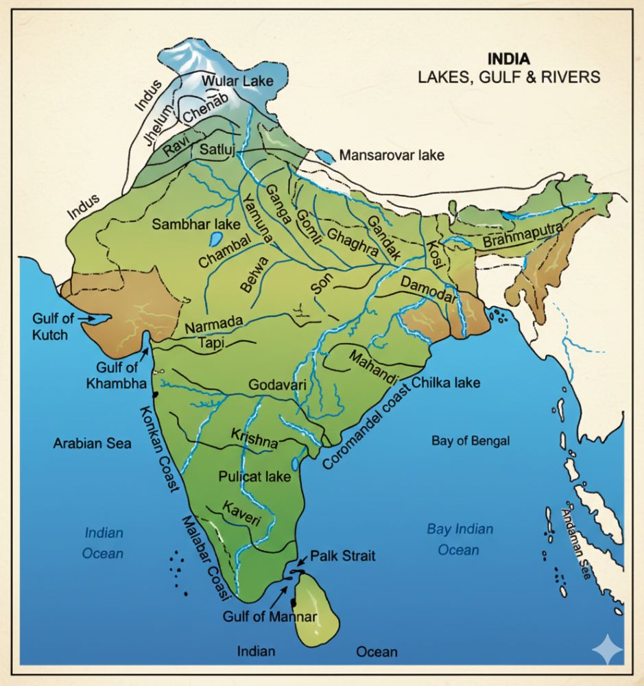
Explain the river system of India with suitable maps.
Answer:
On the basis of origin and direction of flow, the river system of India is broadly divided into two major groups:
- The Himalayan Rivers (North Indian Rivers)
- The Peninsular Rivers (South Indian Rivers)
- The Himalayan Rivers
The Himalayan rivers originate from the glaciers of the Himalayas and flow throughout the year. Hence, they are perennial rivers. There are three major river systems under this group:
- The Indus River System
The Indus River rises near Mount Kailash (6714 m) in Tibet. It has a total length of about 2880 km, of which 709 km flows in India. It flows through deep gorges between the Ladakh and Zaskar ranges in Jammu and Kashmir. The Indus is one of the oldest river systems in the world, though most of its course lies in Pakistan.
The important tributaries of the Indus are Jhelum, Chenab, Ravi, Beas, and Sutlej.
- The Ganga River System
The Ganga is the longest (about 2500 km) and largest river system of India and is known as the National River of India. It has two headstreams—Bhagirathi and Alakananda.
The Bhagirathi rises at Gangotri, and the Alakananda originates near Badrinath in the Garhwal Himalayas. They meet at Devaprayag, from where the river is known as the Ganga. After descending from the Himalayas, the Ganga enters the Northern Plains at Haridwar.
The river flows south-eastward through Uttar Pradesh, Bihar, and West Bengal, enters Bangladesh, where it is known as Padma, and finally drains into the Bay of Bengal.
The important tributaries of the Ganga are Yamuna, Ramganga, Ghaghara, Gandak, Gomati, Bagmati, Kosi, Chambal, Betwa, Son, Ken, and Damodar.
- The Brahmaputra River System
The Brahmaputra River rises near Manasarovar Lake in Tibet, where it is known as Tsangpo. It enters Arunachal Pradesh, flows through Assam, and is known as the Brahmaputra.
It enters Bangladesh, where it joins the Ganga and is called Meghna, and finally empties into the Bay of Bengal.
The total length of the river is about 2900 km, of which 885 km flows in India.
- The Peninsular Rivers
The Peninsular Plateau has a dense network of rivers. Most of these rivers originate from the Western Ghats and Central Highlands. They are mainly seasonal rivers. Based on the direction of flow, they are classified into:
- East-flowing Rivers
- West-flowing Rivers
B.1 East-flowing Rivers
These rivers flow eastward and drain into the Bay of Bengal. They are longer and form large deltas.
The Mahanadi:
The Mahanadi rises in the Sihawa region of Chhattisgarh and flows for about 885 km before joining the Bay of Bengal near Cuttack. Important tributaries are Seonath, Hasdeo, Mand, and Jonk. Dams like Hirakud, Naraj, and Tikarapara are built across this river.
The Godavari:
The Godavari is the longest and largest river of Peninsular India. It rises at Trimbakeshwar near Nashik in Maharashtra and flows for about 1465 km before joining the Bay of Bengal near Kakinada. Its important tributaries include Purna, Penganga, Pranhita, Sabari, Indravathi, and Manjira.
The Krishna:
The Krishna is the second longest east-flowing river of Peninsular India. It rises near Mahabaleshwar in Maharashtra and flows for about 1400 km, joining the Bay of Bengal near Divi Point. Important tributaries are Koyna, Bhima, Tungabhadra, Ghataprabha, Malaprabha, Musi, etc.
The Kaveri:
The Kaveri is a sacred river and rises at Talakaveri in the Brahmagiri range of Kodagu (Coorg), Karnataka. It flows for about 805 km and joins the Bay of Bengal near Kaveripattinam.
Its important tributaries are Arkavathi, Hemavathi, Harangi, Kabini, Shimsha, Bhavani, Amaravathi, and Lakshmanatirtha.
B.2 West-flowing Rivers
The west-flowing rivers are short, swift, and flow into the Arabian Sea. Important west-flowing rivers include Luni, Sabarmati, Mahi, Narmada, Tapi, Mandovi, Zuari, Kali, Sharavathi, Gangavati, Bedti, Netravathi, and Periyar.
Question8.
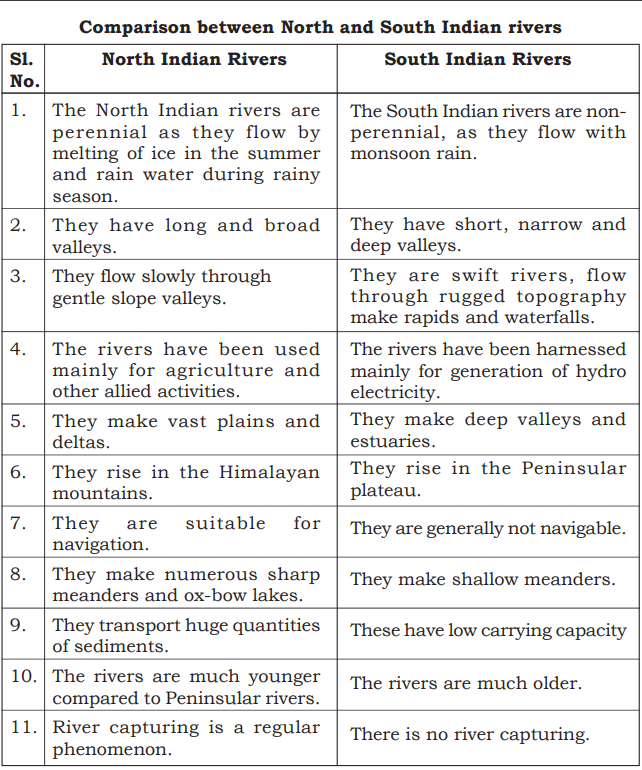
Compare the North Indian rivers with South Indian rivers.
Answer:
Question 9.
Why does River water dispute arise? Mention the important disputes and proposed measures.
Answer:
A river water dispute refers to any disagreement between two or more states regarding the use, distribution, or control of water from an inter-state river or river valley. Water is a vital resource required for domestic use, irrigation, and industrial development. Most rivers in India flow through more than one state, and each state attempts to secure a larger share of river water to meet its growing needs. This competition has led to several river water disputes.
Uneven and seasonal rainfall, increasing population, expansion of irrigation, and industrialization have further intensified these disputes. In recent years, rivers flowing across international boundaries have also become sources of conflict between neighboring countries, making river water disputes a global issue.
Important River Water Disputes in India
Inter-State Disputes:
- Kaveri water dispute – Karnataka, Tamil Nadu, Kerala, and Puducherry
- Krishna water dispute – Karnataka, Maharashtra, and Andhra Pradesh
- Tungabhadra water dispute – Karnataka and Andhra Pradesh
- Mandovi water dispute – Karnataka and Goa
- Narmada water dispute – Gujarat and Madhya Pradesh
- Yamuna water dispute – Uttar Pradesh, Haryana, and Rajasthan
- Godavari water dispute – Maharashtra, Chhattisgarh, and Karnataka
- Ravi and Beas water dispute – Punjab, Haryana, Rajasthan, and Jammu & Kashmir
- Mullaperiyar water dispute – Kerala and Tamil Nadu
International Disputes:
- Jhelum and Chenab water dispute – India and Pakistan
- Brahmaputra water dispute – India and China
- Teesta water dispute – India and Bangladesh
- Barak water dispute – India and Bangladesh
- Indus water dispute – India and Pakistan
Proposed Measures to Solve Water Disputes
- Nationalization of major rivers: Declaring major rivers as national property can ensure equitable distribution among states.
- Central government intervention: National river development schemes with central assistance should be implemented for optimal utilization of water resources.
- Interlinking of rivers: River interlinking helps transfer water from surplus river basins to deficit areas, reducing floods and droughts.
- National Water Grid: A nationwide water grid can facilitate balanced water distribution across regions.
- Efficient water management: Scientific planning, conservation, and proper utilization of water resources are essential for sustainable development.
Question 10.
Briefly explain the importance of inter-linking of Rivers in India.
Answer:
The distribution of rainfall in India is highly uneven and seasonal. The Himalayan rivers are perennial, whereas most Peninsular rivers are seasonal. During the monsoon season, a large quantity of river water is wasted through floods and flows into the sea, while during the dry season many regions face acute water scarcity.
Different parts of the country receive varying amounts of rainfall, resulting in floods in some regions and droughts or famine in others. Inter-linking of rivers helps in transferring surplus water from flood-prone areas to drought-prone regions, thereby ensuring optimum utilization of water resources. This system is also known as the National Water Grid.
Inter-linking of rivers helps to:
- Control floods and reduce drought conditions
- Provide assured irrigation to dry regions
- Improve water availability for domestic and industrial use
- Promote balanced regional development
The river inter-linking project consists of two major components:
- Northern Himalayan River Development Component:
This involves the construction of dams on the Ganga and Brahmaputra rivers for water storage. Canals would transfer surplus water from the eastern tributaries of the Ganga to the western regions. The Brahmaputra and its tributaries would be linked with the Ganga, and the Ganga with the Mahanadi. This component would support irrigation and generate hydroelectric power. - Southern Peninsular River Development Component:
This focuses on linking seasonal rivers of Peninsular India to ensure year-round water supply and agricultural development.
Thus, inter-linking of rivers plays a crucial role in water conservation, agricultural growth, and sustainable development in India.
Additional Questions and Answer:
I. One Mark Questions & Answers
Question 1.
What is meant by physiography?
Answer:
Physiography is the study of physical features of the Earth’s surface.
Question 2.
Name the oldest mountain range in India.
Answer:
The Aravalli Range.
Question 3.
Which river forms the largest delta in the world?
Answer:
The Ganga–Brahmaputra river system.
Question 4.
Name the highest peak of the Himalayas in India.
Answer:
Kanchenjunga.
Question 5.
Which plateau is known as the lava plateau of India?
Answer:
The Deccan Plateau.
Question 6.
Name the capital of Lakshadweep Islands.
Answer:
Kavaratti.
Question 7.
Which coastal plain receives the first South-West monsoon rainfall?
Answer:
The West Coastal Plains (Malabar Coast).
Question 8.
What is the shape of the Peninsular Plateau?
Answer:
Inverted triangular shape.
II. Two Mark Questions & Answers
Question 1.
What are Doons? Give an example.
Answer:
Doons are longitudinal valleys found between the Lesser Himalayas and the Siwaliks. Example: Dehra Doon.
Question 2.
Mention any two features of the Northern Plains.
Answer:
- Very fertile alluvial soil
- Dense population and intensive agriculture
Question 3.
Write any two differences between Western Ghats and Eastern Ghats.
Answer:
- Western Ghats are continuous, Eastern Ghats are discontinuous
- Western Ghats are higher than Eastern Ghats
Question 4.
What is a river basin?
Answer:
A river basin is the area drained by a river along with its tributaries.
Question 5.
Mention any two west-flowing rivers of India.
Answer:
Narmada and Tapi.
Question 6.
Why are the Peninsular rivers seasonal?
Answer:
Because they depend mainly on monsoon rainfall.
CLICK HERE TO DOWNLOAD Physiography PDF
CLICK HERE TO WATCH Physiography VIDEO
Physiography of India is an important chapter in 1st PUC Geography that explains the physical divisions of India, Himalayan system, Northern Plains, Peninsular Plateau, Coastal Plains, Islands, river systems, and inter-linking of rivers.
This page provides clear notes and additional questions and answers (1, 2, and 5 marks) based on the Karnataka State Board syllabus, written in simple, textbook-oriented language to help students score better in exams.
📘 For more PUC Geography notes and question banks, visit EasyLearnNow.com regularly.