1st PUC Geography Question and Answer – Atmosphere
Looking for 1st PUC Geography textbook answers? You can download Chapter 4: Atmosphere Questions and Answers PDF, Notes, and Summary here. 1st PUC Geography solutions follow the Karnataka State Board Syllabus, making it easier for students to revise and score higher in exams.
Karnataka 1st PUC Geography Textbook Answers—Reflections Chapter 4
Atmosphere Questions and Answers, Notes, and Summary
1st PUC Geography Chapter 5
Atmosphere
Scroll Down to Download Atmosphere PDF
I. Answer the following in a word or a sentence each.
Question 1.
Define Atmosphere.
Answer:
The thin layer of gases, water vapour, and dust particles surrounding the Earth is called atmosphere.
Question 2.
What is the percentage of Nitrogen in the Atmosphere?
Answer:
About 78% of the atmosphere is Nitrogen.
Question 3.
Why is Carbon dioxide important in the Atmosphere?
Answer:
Carbon dioxide is essential for photosynthesis and helps in trapping heat to keep the Earth warm.
Question 4.
Which layer of Atmosphere is called ‘Weather manufacturer’?
Answer:
Troposphere.
Question 5.
In which layer do you find Aurora?
Answer:
Aurora is found in the Thermosphere (Ionosphere).
Question 6.
What is Stratopause?
Answer:
The boundary between the Stratosphere and Mesosphere is called Stratopause.
Question 7.
Which is the coldest layer in the Atmosphere?
Answer:
Mesosphere.
Question 8.
Define Insolation.
Answer:
The incoming solar radiation received by the Earth is called insolation.
Question 9.
What is Convection?
Answer:
The transfer of heat by the upward movement of heated air or liquid is called convection.
Question 10.
Mention the average atmospheric pressure of the Earth.
Answer:
1013.25 millibars at sea level.
Question 11.
How many pressure belts are there in the globe?
Answer:
There are seven pressure belts on the globe.
Question 12.
Define Doldrums.
Answer:
The equatorial low pressure belt with calm winds is called doldrums.
Question 13.
Where do we find ‘Horse latitudes’?
Answer:
They are found between 25° and 35° North and South latitudes.
Question 14.
Name the instrument used to measure speed of the Wind.
Answer:
Anemometer.
Question 15.
What is ITCZ?
Answer:
Inter-Tropical Convergence Zone is the region where the trade winds meet near the equator.
Question 16.
Where do we see ‘Roaring Forties’?
Answer:
They are found around 40° South latitude.
Question 17.
Why are Tropical cyclones more dangerous?
Answer:
They cause heavy rainfall and very high-speed winds leading to destruction.
Question 18.
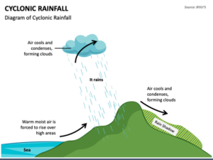
What is Rain shadow region?
Answer:
The dry area found on the leeward side of a mountain is called rain shadow region.
Question 19.
Which instrument is used to measure the amount of Rainfall?
Answer:
Rain gauge.
Question 20.
Mention any two factors that determine the climate of a place.
Answer:
Latitude and distance from the sea.
II Answer the following in two or three sentences each.
Question 1.
Mention any two components of Atmosphere.
Answer:
Two important components of the atmosphere are gases (like nitrogen and oxygen) and water vapour. Dust particles are also present and help in condensation of water vapour.
Question 2.
Name any four important gases present in the atmosphere.
Answer:
Four important gases in the atmosphere are Nitrogen, Oxygen, Carbon dioxide, and Argon. These gases are essential for life, weather, and maintaining the Earth’s temperature.
Question 3.
Why is Troposphere called ‘Region of Mixing’?
Answer:
Troposphere is called the ‘Region of Mixing’ because all weather changes like clouds, rain, winds, and thunderstorms occur in this layer. Air is constantly in motion, mixing the gases and heat.
Question 4.
What is the role of Ionosphere in the Atmosphere?
Answer:
The Ionosphere, part of the thermosphere, contains ions that reflect radio waves back to Earth. It also protects us from meteors and produces Aurora Borealis and Aurora Australis.
Question 5.
Mention the features of Inversion of Temperature.
Answer:
Inversion of temperature occurs when temperature increases with height instead of decreasing. It is common in mountain valleys during winter, with clear skies, slow winds, and less cloud cover.
Question 6.
Why do Pressure belts shift?
Answer:
Pressure belts shift because the apparent position of the Sun changes during the year due to the Earth’s revolution. The belts move northwards or southwards following the Sun’s migration.
Question 7.
Name the two important Trade winds.
Answer:
The two important trade winds are the North-East Trade Winds in the Northern Hemisphere and South-East Trade Winds in the Southern Hemisphere. They blow from the subtropical high pressure belts towards the equatorial low pressure belt.
Question 8.
How is Sea breeze formed?
Answer:
Sea breeze is formed during the day when land heats up faster than the sea. Warm air rises over the land, creating low pressure, and cooler air from the sea moves in to replace it.
Question 9.
Mention the features of a Cyclone.
Answer:
Cyclones are low pressure systems with winds spiralling towards the centre. They bring heavy rainfall, strong winds, and in tropical regions they can cause devastation.
Question 10.
How is Mountain rainfall caused?
Answer:
Mountain rainfall, or Orographic rainfall, occurs when moist winds are forced to rise over mountains. As the air rises, it cools and condenses, causing heavy rainfall on the windward side, while the leeward side remains dry.
III Answer the following.
Question 1.
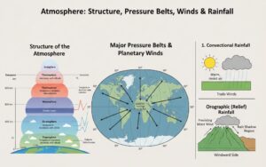
Explain the structure of the Atmosphere.
Answer:
The atmosphere extends up to about 1,600 km above the Earth’s surface, but 99% of its mass is found within 32 km. It is divided into five main layers based on temperature and composition.
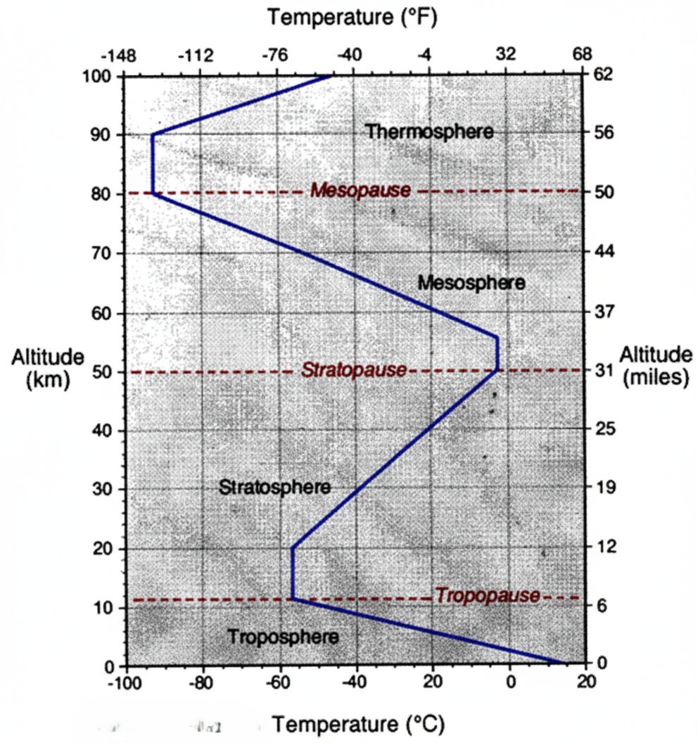
- Troposphere
It is the lowest layer where all weather phenomena occur, hence called the weather manufacturer. It extends up to about 8 km at the poles and 18 km at the equator. Temperature decreases with height at the normal lapse rate. The upper boundary is called Tropopause. - Stratosphere
It extends up to 50 km above the Earth’s surface. This layer is free from dust and clouds, making it ideal for jet aircraft. The ozone layer, which absorbs harmful ultraviolet rays, is found here. The upper boundary is Stratopause. - Mesosphere
It extends from 50 km to 80 km. It is the coldest layer of the atmosphere, where temperature can fall to –100°C. The boundary between mesosphere and thermosphere is called Mesopause. - Thermosphere (Ionosphere)
This layer extends from 80 km to 600 km. It contains charged particles called ions, which reflect radio waves. Aurora Borealis and Aurora Australis occur in this layer. - Exosphere
It is the outermost layer extending up to about 1,000 km. Air is extremely thin and gravity is very weak in this layer.
Question 2.
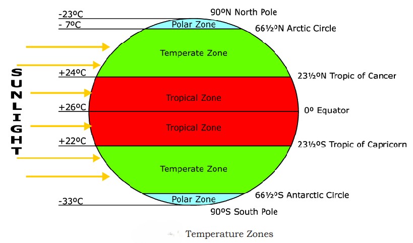
Briefly explain the factors affecting the distribution of temperature.
Answer:
The distribution of temperature on the surface of the Earth is not uniform. It varies from region to region due to several physical factors. The important factors affecting the distribution of atmospheric temperature are:
- a) Latitude or distance from the Equator:
Places near the equator receive direct sun rays and hence experience high temperature. In higher latitudes, the sun rays are slanting and pass through a greater thickness of the atmosphere, losing much of their heat. Therefore, temperature decreases from the equator towards the poles. - b) Altitude:
Temperature decreases with increase in height. This is because air near the Earth’s surface is denser and contains more heat-absorbing gases like carbon dioxide and water vapour. Temperature decreases at an average rate of 1°C for every 165 metres or 6.4°C per 1000 metres. - c) Distance from the Sea:
Land gets heated and cooled faster than water. Coastal areas experience moderate temperatures due to the influence of the sea, while interior regions experience extreme temperatures during summer and winter. - d) Ocean Currents:
Warm ocean currents increase the temperature of coastal regions, whereas cold ocean currents decrease the temperature. For example, the Gulf Stream warms the eastern coast of the USA, while the California cold current cools the western coast. - e) Winds:
Winds blowing from warm regions raise the temperature of a place, while winds from cold regions lower it. Sea winds generally bring moisture and moderate temperatures, whereas land winds are dry. - f) Clouds:
Clouds reduce temperature during the day by blocking insolation and prevent heat loss at night by trapping terrestrial radiation. Clear skies allow more heating during the day and rapid cooling at night.
Question 3.
Describe the major pressure belts of the world with a neat diagram.
Answer:
The distribution of atmospheric pressure on the Earth’s surface is not uniform. It varies from place to place and from time to time due to unequal heating of the Earth and the rotation of the Earth. Any area where air pressure is higher than the surrounding areas is called a high pressure area, and where it is lower is called a low pressure area.
There are seven major pressure belts on the Earth—four high pressure belts and three low pressure belts.

1) Equatorial Low Pressure Belt (Doldrums)
This belt lies between 5° North and 5° South latitudes. The Sun’s rays fall almost vertically throughout the year, resulting in high temperature. The heated air expands and rises, creating low pressure. Horizontal winds are weak and calm conditions prevail, hence it is called the Doldrums. It is also the zone of convergence of trade winds and receives heavy convectional rainfall.
2) Sub-Tropical High Pressure Belts (Horse Latitudes)
These belts are found between 30° and 35° latitudes in both hemispheres. The air that rises at the equator cools and descends in these regions, forming high pressure belts. Trade winds and westerlies originate from these belts. These belts are also known as Horse Latitudes, as early sailors faced calm conditions and sometimes had to throw horses overboard to save drinking water.
There are two belts:
- North Sub-tropical High Pressure Belt
- South Sub-tropical High Pressure Belt
3) Sub-Polar Low Pressure Belts
These belts lie between 60° and 70° latitudes in both hemispheres. They are formed due to the convergence of warm westerlies and cold polar winds, causing air to rise and create low pressure. These regions are marked by stormy weather, especially during winter.
There are two belts:
- North Sub-polar Low Pressure Belt
- South Sub-polar Low Pressure Belt
Question 4.
Explain the planetary winds with the help of a diagram.
Answer:
Planetary winds are the winds that blow permanently from the high-pressure belts to the low-pressure belts in a definite direction throughout the year. They are also known as permanent winds or prevailing winds.
Characteristics of Planetary Winds
- They are directly related to the pressure belts of the Earth and blow from high pressure to low pressure areas.
- They are regular and permanent in nature.
- Due to the Coriolis force, they deflect:
- To the right in the Northern Hemisphere
- To the left in the Southern Hemisphere
- With the seasonal shifting of pressure belts, planetary winds also shift slightly northward in summer and southward in winter.
- They blow over vast areas of the Earth.
Planetary winds include:
- Trade Winds
- Westerlies (Anti-trade winds)
- Polar Winds
- Trade Winds
Trade winds blow from the sub-tropical high pressure belts towards the equatorial low pressure belt.
- Found between 8° and 30° latitudes on both sides of the equator
- Blow from the east, hence called Tropical Easterlies
- Blow as:
- North-East Trade Winds in the Northern Hemisphere
- South-East Trade Winds in the Southern Hemisphere
- Generally dry as they blow from cooler to hotter regions
- When they pass over oceans, they collect moisture and bring heavy rainfall to the eastern coasts of continents
- Anti-Trade Winds (Westerlies)
The winds that blow from the sub-tropical high pressure belts towards the sub-polar low pressure belts are called Anti-trade winds or Westerlies.
- Found between 40° and 65° latitudes in both hemispheres
- Blow:
- South-West to North-East in the Northern Hemisphere
- North-West to South-East in the Southern Hemisphere
- Blow from warmer regions to colder regions
- Bring rainfall throughout the year and greatly influence the climate of temperate regions
- Polar Winds
Polar winds blow from the polar high pressure belts towards the sub-polar low pressure belts.
- Blow as:
- North-East winds in the Northern Hemisphere
- South-East winds in the Southern Hemisphere
- Originate from snow-covered polar regions, hence extremely cold and dry
- More regular and constant in the Southern Hemisphere
Question 17.
Wha is Rainfall? Explain the types of rainfall with neat diagrams.
Answer:
Rainfall is a form of precipitation in which water vapour present in the atmosphere condenses and falls to the earth’s surface in the form of water droplets. It occurs when warm, moist air rises, cools below the dew point, and condensation takes place. Adequate humidity, cooling of air, and upward movement of air are essential conditions for rainfall.
On the basis of the mechanism of uplift and cooling of air, rainfall is classified into three types:
- Convectional Rainfall
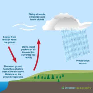
Convectional rainfall occurs due to intense heating of the earth’s surface by solar radiation. The heated surface warms the air above it, making the air light and buoyant. This warm, moisture-laden air rises rapidly in a vertical manner. As it ascends, it cools below the dew point, leading to condensation and formation of cumulonimbus clouds. This results in heavy rainfall accompanied by thunder and lightning.
This type of rainfall is common in equatorial regions where high temperatures, excessive evaporation, and calm air conditions prevail throughout the year. In tropical regions, convectional rainfall generally occurs during the summer afternoons.
- Orographic Rainfall
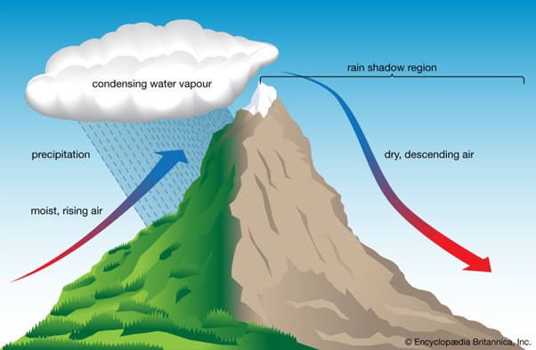
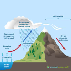
Orographic rainfall is caused by the relief features of the land. When moisture-laden winds from the sea encounter a mountain barrier, they are forced to ascend along the windward slope. As the air rises, it expands and cools. Cooling below the dew point results in condensation and cloud formation, leading to rainfall on the windward side of the mountain.
The leeward side of the mountain receives little or no rainfall and is known as the rain shadow region. Orographic rainfall is common in regions where mountain ranges run parallel to the coast and onshore winds prevail. This type of rainfall plays a major role in monsoon regions and accounts for a large proportion of the world’s rainfall.
- Cyclonic Rainfall
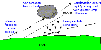
Cyclonic rainfall is associated with cyclones and depressions, and is common in temperate regions. It occurs when warm and cold air masses meet. The warm air, being lighter, is forced to rise over the cold air along a фронт (front). As the warm air ascends, it cools, condenses, and produces widespread rainfall.
Cyclonic rainfall is usually moderate to heavy and covers a large area. It is often accompanied by strong winds and overcast skies.
Additional important questions and answers
One Mark Questions
Question 1.
What is atmosphere?
Answer:
Atmosphere is the thick blanket of gases surrounding the earth.
Question 2.
What is insolation?
Answer:
Insolation is the incoming solar radiation received by the earth from the sun.
Question 3.
Name the major gas found in the atmosphere.
Answer:
Nitrogen.
Question 4.
What is humidity?
Answer:
Humidity is the amount of water vapour present in the air.
Question 5.
What is condensation?
Answer:
Condensation is the process by which water vapour changes into liquid water.
Two Mark Questions
Question 1.
Mention any two functions of the atmosphere.
Answer:
- It protects life from harmful solar radiation.
- It helps in maintaining temperature balance on the earth.
Question 2.
What is air pressure?
Answer:
Air pressure is the weight of the air column exerted on the earth’s surface.
Question 3.
Name the layers of the atmosphere.
Answer:
Troposphere, Stratosphere, Mesosphere, Thermosphere, and Exosphere.
Question 4.
What are pressure belts?
Answer:
Pressure belts are zones of uniform atmospheric pressure distributed across the earth’s surface.
Question 5.
What is dew point?
Answer:
Dew point is the temperature at which air becomes saturated and condensation begins.
Five Mark Questions
Question 1.
Explain the composition of the atmosphere.
Answer:
The atmosphere is composed of a mixture of gases, water vapour, and dust particles.
- Nitrogen (78%): Helps in controlling combustion and supports plant life.
- Oxygen (21%): Essential for respiration and combustion.
- Other gases (1%): Includes argon, carbon dioxide, ozone, etc.
- Water vapour: Causes clouds, rainfall, and regulates temperature.
- Dust particles: Help in condensation of water vapour.
Question 2.
Describe the structure of the atmosphere.
Answer:
The atmosphere is divided into five layers based on temperature variation:
- Troposphere – Lowest layer where weather phenomena occur.
- Stratosphere – Contains ozone layer which absorbs ultraviolet rays.
- Mesosphere – Temperature decreases with height; meteors burn here.
- Thermosphere – Extremely hot; contains ionosphere.
- Exosphere – Outermost layer merging into space.
Question 3.
Explain the importance of ozone layer.
Answer:
- Protects living beings from harmful ultraviolet rays
- Helps in maintaining earth’s temperature
- Prevents skin cancer and eye diseases
- Essential for sustaining life on earth
Question 4.
Describe the factors affecting temperature distribution. Answer:
- Latitude
- Altitude
- Distance from the sea
- Prevailing winds
- Ocean currents
Question 5.
Explain the water cycle.
Answer:
The water cycle is the continuous movement of water between land, ocean, and atmosphere through evaporation, condensation, precipitation, and runoff. It maintains the balance of water on earth and supports life.