1st PUC Geography Chapter 8 Q&A – India
Looking for 1st PUC Geography Chapter 8 Q&A? Here you can download the complete Chapter 8: India Questions and Answers, notes, and summary. These 1st PUC Geography solutions follow the Karnataka State Board syllabus, making it easier for students to revise and score higher in exams.
1st PUC Geography Chapter 8
India
Scroll Down to Download India PDF
I. One Mark Questions – 1st PUC Geography Chapter 8 Q&A
Question 1.
State the geographical location of India.
Answer:
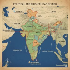
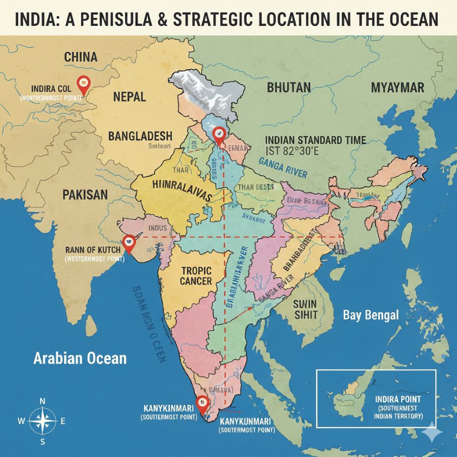
India extends between 8°4′ N to 37°6′ N latitudes and 68°7′ E to 97°25′ E longitudes.
Question 2.
Name the southernmost and northernmost points of main land of India.
Answer:
The northernmost point of the Indian mainland is Indira Col in Jammu and Kashmir, while the southernmost point is Kanyakumari (Cape Comorin) in Tamil Nadu.
Question 3.
In which Island of India, is ‘Indira Point’ situated?
Answer:
Indira Point is situated in the Great Nicobar Island.
Question 4.
What is the total geographical area of India?
Answer:
The total geographical area of India is 32,87,263 square kilometres.
Question 5.
Mention the International boundary between India and China.
Answer:
The international boundary between India and China is called the McMahon Line.
II. Two Marks Questions – 1st PUC Geography Chapter 8 Q&A
Question 1.
Write the latitudinal and longitudinal extent of India.
Answer:
- The latitudinal extent of India is 8°4′ N to 37°6′ N and the longitudinal extent is 68°7′ E to 97°25′ E.
- The latitudinal and longitudinal extent of India is about 30°.
- The country stretches 3214 km from North to South and 2933 km from West to East.
Question 2.
Name the water bodies that surround India.
Answer:
- India is a peninsula located at the northern tip of the Indian Ocean.
- It is bordered by the Arabian Sea in the west, the Indian Ocean in the south and the Bay of Bengal in the east.
Question 3.
Which latitude and longitude passes in the centre of the country?
Answer:
- The Tropic of Cancer (23½° N latitude) passes through the middle of India and divides the country into almost two equal halves.
- The 82½° E longitude, passing through Allahabad, is recognized as the standard longitude of India to fix Indian Standard Time.
Question 4.What is the growth rate of population and total
population of India according to 2011 census?
Answer:
- According to the 2011 Census, the total population of India was 121.6 crore (1216 million or 1.21 billion).
- This constitutes about 17.45% of the total world population.
Question 5.
Name the international boundaries between India & Pakistan and India & Afghanistan.
Answer:
- The Radcliffe Line demarcates the boundary between India and Pakistan and was drawn by Sir Cyril Radcliffe.
- The Durand Line forms the boundary between India and Afghanistan and was demarcated by Mortimer Durand.
III. Five Marks Questions – 1st PUC Geography Chapter 8 Q&A
Question 1.
Explain the location, size and frontiers of India.
Answer:
Location:
The mainland of India extends between 8°4′ N to 37°6′ N latitude and 68°7′ E to 97°25′ E longitude.
The latitudinal and longitudinal extent of India is about 30°.
The country stretches 3214 km from North to South and 2933 km from West to East.
- Northernmost point: Indira Col, Jammu & Kashmir
- Southernmost point (mainland): Kanyakumari (Cape Comorin), Tamil Nadu
- Westernmost point: Rann of Kutch, Gujarat
- Easternmost point: Luhit, Arunachal Pradesh
The territorial limit of India extends up to 6°45′ N latitude, at Indira Point in Great Nicobar Island.
India is a peninsular country, surrounded by:
- Arabian Sea in the west
- Indian Ocean in the south
- Bay of Bengal in the east
It is bordered by land in the north by China, Nepal, Bhutan, etc.
The Tropic of Cancer (23½° N latitude) passes through the middle of India, dividing the country into almost two equal halves.
The 82½° E longitude, passing through Allahabad, is the standard longitude used to fix Indian Standard Time (IST).
Size:
- India is the 7th largest country in the world, after Russia, Canada, China, USA, Brazil, and Australia.
- It has a total geographical area of 32,87,263 sq. km, which is about 2.4% of the Earth’s total land area.
- India is the second most populous country in the world after China.
- According to the 2011 Census, India’s population was 121.6 crore (1.216 billion), which is about 17.45% of the world population.
- India has 28 states, 6 union territories, and 1 National Capital Region (New Delhi).
Frontiers:
India has a land frontier of 15,200 km, extending from Gujarat in the west to West Bengal in the east.
- Northern boundary: Himalayas (India & China)
- Western & north-western boundary: Thar Desert (India & Pakistan)
- Eastern boundary: Hills of northeast India (India & Myanmar)
India shares borders with seven countries:
- Pakistan and Afghanistan – Northwest
- China, Nepal, Bhutan – North
- Bangladesh and Myanmar – East
Important international boundary lines:
- Durand Line – India & Afghanistan (80 km) by Mortimer Durand
- McMahon Line – India & China (PRC) (3488 km) by Henry McMahon
- Radcliffe Line – India & Pakistan (2910 km) by Sir Cyril Radcliffe
- India & Bangladesh – 4097 km
Maritime boundary:
- Sri Lanka, an island country to the southeast, is separated from India by the Palk Strait and the Gulf of Mannar.
- Mainland coastline: 6,100 km
- Total coastline including islands: 7,516 km
- Territorial waters: extend 12 nautical miles (22.2 km) from the baseline.
Additional Questions and Answers
I. One Mark Questions & Answers
Question 1.
What is the standard longitude of India?
Answer:
82½° E longitude.
Question 2.
Which Tropic passes through the middle of India?
Answer:
Tropic of Cancer (23½° N latitude).
Question 3.
Name the southernmost point of mainland India.
Answer:
Kanyakumari (Cape Comorin), Tamil Nadu.
Question 4.
How many states and union territories are there in India?
Answer:
28 states and 6 union territories.
Question 5.
Which line demarcates the boundary between India and Pakistan?
Answer:
Radcliffe Line.
II. Two Marks Questions & Answers
Question 1.
What are the latitudinal and longitudinal extent of India?
Answer:
- India extends between 8°4′ N to 37°6′ N latitude and 68°7′ E to 97°25′ E longitude.
- The latitudinal and longitudinal extent is about 30°, stretching 3214 km north–south and 2933 km west–east.
Question 2.
Name the water bodies surrounding India.
Answer:
India is a peninsula surrounded by the Arabian Sea in the west, Indian Ocean in the south, and Bay of Bengal in the east.
Question 3.
Which countries share land borders with India?
Answer:
Pakistan, Afghanistan (northwest), China, Nepal, Bhutan (north), Bangladesh, Myanmar (east).
Question 4.
What is the total geographical area and population of India?
Answer:
India’s total area is 32,87,263 sq. km, and its population (2011) was 121.6 crore, about 17.45% of the world’s population.
Question 5.
Where is Indira Point located and why is it important?
Answer:
Indira Point is in Great Nicobar Island and is the southernmost territorial point of India.
III. Five Marks Questions & Answers
Question 1.
Explain the location of India with reference to neighbouring countries and oceans.
Answer:
- India is located in the southern part of Asia and lies at the northern tip of the Indian Ocean.
- It is a peninsula with water on three sides: Arabian Sea (west), Indian Ocean (south), Bay of Bengal (east).
- In the north, it shares land borders with China, Nepal, and Bhutan; in the northwest with Pakistan and Afghanistan; and in the east with Bangladesh and Myanmar.
- The Tropic of Cancer passes through the middle of India, dividing it into North and South India.
- India’s standard longitude (82½° E) passes through Allahabad to maintain Indian Standard Time.
- Its strategic location makes it important for trade, defense, and cultural exchange.
Question 2.
Describe the size and population of India.
Answer:
- India is the 7th largest country in the world, covering 32,87,263 sq. km, which is about 2.4% of the Earth’s land area.
- It is the second most populous country after China, with a population of 121.6 crore (2011 Census), which is 17.45% of the world population.
- India has 28 states and 6 union territories, with diverse geography, culture, and climate.
- The mainland stretches 3214 km north–south and 2933 km west–east, giving it significant geographic and strategic importance.
Question 3.
Explain the frontiers of India.
Answer:
- India has a land frontier of 15,200 km and a coastline of 6,100 km (7,516 km including islands).
- Natural boundaries include the Himalayas in the north and the Thar Desert in the west & northwest.
- India shares borders with seven countries: Pakistan, Afghanistan, China, Nepal, Bhutan, Bangladesh, and Myanmar.
- Important boundary lines are the Radcliffe Line (India–Pakistan), Durand Line (India–Afghanistan), and McMahon Line (India–China).
- Maritime boundaries include separation from Sri Lanka by the Palk Strait and Gulf of Mannar.
CLICK HERE TO DOWNLOAD India PDF
CLICK HERE TO WATCH India VIDEO
Welcome to EasyLearnNow’s 1st PUC Geography India chapter Q&A! Here, students can find detailed questions and answers on India’s location, size, frontiers, population, and physical features. Perfect for exam preparation, quick revision, and understanding key concepts, this guide makes learning Geography simple and effective.