1st PUC Geography Chapter 6 Q&A – Hydrosphere
Looking for 1st PUC Geography Chapter 6 Q&A? Here you can download the complete Chapter 6: Hydrosphere Questions and Answers, notes, and summary. These 1st PUC Geography solutions follow the Karnataka State Board syllabus, making it easier for students to revise and score higher in exams.
1st PUC Geography Chapter 6
Hydrosphere
Scroll Down to Download Hydrosphere
I. One Mark Questions – 1st PUC Geography Chapter 6 Q&A
Question 1.
What is Hydrological cycle?
Answer:
The cyclic movement of water between the atmosphere and the Earth’s surface through evaporation, condensation and precipitation is called the hydrological cycle.
Question 2.
Define Oceanography.
Answer:
Oceanography is the scientific study of seas and oceans, including their temperature, salinity, depth, currents and ocean floor.
Question 3.
Which instrument is used to measure depth of the Ocean?
Answer:
Fathomometer (Eco sounder) is used to measure the depth of the ocean.
Question 4.
Name the region which covers largest area in the ocean floor.
Answer:
Deep sea plains cover the largest area of the ocean floor.
Question 5.
What is Salinity?
Answer:
Salinity is the total amount of dissolved salts present in ocean water.
Question 6.
Which lines are drawn on the map to show places having same salinity?
Answer:
Isohalines are the lines drawn to show places having the same salinity.
Question 7.
What are Sea waves?
Answer:
Sea waves are the undulations found on the surface of the sea caused mainly by wind.
Question 8.
Where do we find the ‘Agulhas current’?
Answer:
The Agulhas current is found along the eastern coast of South Africa in the Indian Ocean.
Question 9.
How does a tide occur?
Answer:
A tide occurs due to the gravitational pull of the Moon, the Sun and the centrifugal force of the Earth.
Question 10.
What is Tidal period?
Answer:
The time between successive high tide and low tide is known as the tidal period.
II. Two Marks Questions – 1st PUC Geography Chapter 6 Q&A
Question 1.
Name the four submarine relief features of the Ocean floor.
Answer:
The four submarine relief features of the ocean floor are the Continental Shelf, Continental Slope, Deep Sea Plains and Ocean Deeps or Trenches.
Question 2.
Mention the important features of Continental Shelf.
Answer:
The continental shelf is the shallow submerged extension of the continent with a depth ranging from 20 to 600 metres. It is rich in marine resources, fishing grounds and contains deposits of oil and natural gas.
Question 3.
Why is Ocean deep or Trench important in the Ocean bottom?
Answer:
Ocean deeps or trenches are the deepest parts of the ocean floor formed due to subduction of oceanic crust. They are important because major earthquakes and tsunamis originate in these regions.
Question 4.
State any four factors that influence on the distribution of temperature in the ocean.
Answer:
The distribution of ocean temperature is influenced by latitude, prevailing winds, ocean currents and unequal distribution of land and water.
Question 5.
Mention any four dissolved minerals in the Ocean water.
Answer:
Sodium chloride, magnesium chloride, magnesium sulphate and calcium sulphate are four dissolved minerals found in ocean water.
Question 6.
What factors affect the salinity in the Ocean water?
Answer:
Salinity is affected by evaporation, precipitation, mixing of fresh water from rivers and glaciers, and the action of winds and ocean currents.
Question 7.
Name the two types of Ocean currents. Where are they found?
Answer:
The two types of ocean currents are warm currents and cold currents. Warm currents flow from equatorial regions towards the poles, while cold currents flow from polar regions towards the equator.
Question 8.
Mention any four South Indian Ocean currents.
Answer:
South Equatorial Current, Mozambique Current, Madagascar Current and Agulhas Current are the important South Indian Ocean currents.
Question 9.
Distinguish between High tide and Low tide.
Answer:
High tide is the rise of sea level due to gravitational pull of the Moon and the Sun. Low tide is the fall of sea level when the water level recedes.
Question 10.
Mention any four uses of tides.
Answer:
Tides help navigation by increasing water depth in harbours, clean river mouths and ports, support fishing activities and help in the generation of tidal energy.
III. Five Marks Questions – 1st PUC Geography Chapter 6 Q&A
Question 1.
Explain the topography of the Ocean floor with a diagram.
Answer:
On the basis of depth and relief, the ocean floor is divided into four major zones or submarine relief features. They are:
- Continental Shelf
The gently sloping submerged extension of the continent is called the continental shelf. It extends from the coastline to a depth of about 180–200 metres. The continental shelf has a very gentle slope and an average width of about 48 km, though it varies from place to place.
The width of the shelf depends upon the nature of the coastal land. It is wide along low-lying plains and narrow or almost absent along mountainous coasts. Continental shelves are rich in fishing grounds and mineral resources like petroleum and natural gas.
- Continental Slope
The continental slope is the steep slope that descends from the edge of the continental shelf to the deep sea plains. It is a transitional zone between the continental shelf and deep sea plains.
Its depth ranges from about 200 metres to 3,600 metres, and its gradient varies between 2° and 5°. It occupies nearly 8.5% of the total area of the ocean floor. Submarine canyons are the most important features found in this region.
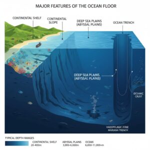
- Deep Sea Plains
The deep sea plains, also known as abyssal plains, are vast, flat and gently rolling regions of the ocean floor. They lie between 3,000 and 6,000 metres below sea level.
They cover the largest area of the ocean floor (about 82.7%). These plains are covered with fine sediments called oozes, formed from the remains of marine organisms and volcanic dust.
- Ocean Deeps or Trenches
The ocean deeps or trenches are long, narrow and extremely deep depressions found on the ocean floor. They are the deepest parts of the oceans and cover about 1–1.2% of the ocean floor.
They are mainly formed due to tectonic activities like subduction and are associated with earthquakes and volcanoes. There are 57 known ocean deeps, of which 32 are in the Pacific Ocean, 19 in the Atlantic Ocean, and 6 in the Indian Ocean.
The Challenger Deep, located in the Mariana Trench in the Pacific Ocean, is the deepest point on the Earth’s sea floor.
Question 2.
Describe the salient features of Salinity of the Ocean water.
Answer:
Salinity of ocean water refers to the total amount of dissolved solids or salts present in ocean water. Ocean water contains various chemical elements and minerals, of which sodium chloride is the most important constituent. Other salts such as magnesium chloride, magnesium sulphate, calcium sulphate and potassium sulphate are also present.
The salinity of ocean water is mainly due to the continuous supply of mineral salts by rivers, which carry dissolved salts from the land to the seas and oceans. Evaporation of sea water also increases salinity, as water evaporates while salts remain behind. Salinity is measured in grams per kilogram of sea water and is expressed as parts per thousand (ppt). The average salinity of ocean water is 35 ppt, which means 35 grams of salt in 1000 grams of sea water.
Salinity is influenced by factors such as evaporation, precipitation, mixing of fresh water from rivers, groundwater and glaciers, and the action of winds and ocean currents. High evaporation increases salinity, while heavy rainfall and fresh water inflow reduce it.
Latitude also plays an important role in the distribution of salinity. Regions near the Tropic of Cancer and Tropic of Capricorn record high salinity due to high temperature, greater evaporation and low rainfall. The equatorial regions have low salinity because of heavy rainfall, while the polar regions record the least salinity due to low evaporation and the presence of ice.
Question 3.
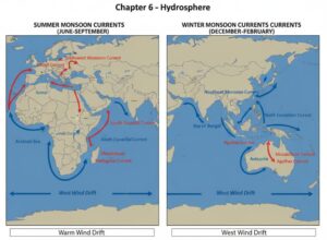
Explain the Indian Ocean currents with the help of Maps.
Answer:
The Indian Ocean differs from other oceans in the pattern of its currents. This is mainly due to the shape of surrounding landmasses, the limited extent of the ocean in the north, and the seasonal reversal of monsoon winds. The Indian Ocean currents are broadly divided into North Indian Ocean currents and South Indian Ocean currents.
- a) North Indian Ocean currents
The currents of the North Indian Ocean are greatly influenced by monsoon winds and hence change their direction twice a year.
During the summer season, the south-west monsoon winds influence the ocean currents. The current flows off the coast of Somalia as the Somali Current and drifts across the Arabian Sea as the South-West Monsoon Drift. It then flows along the western and eastern coasts of India, enters the Bay of Bengal and finally joins the North Equatorial Current, forming a clockwise circulation.
During the winter season, the north-east monsoon winds reverse the direction of the currents. The current starts from the Strait of Malacca, flows westward along the eastern and western coasts of India as the North-East Monsoon Drift. It then turns near the Gulf of Aden, flows southward along the Somali coast, and finally joins the North Equatorial Current, forming an anticlockwise circulation.
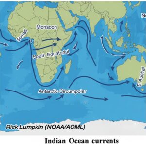
- b) South Indian Ocean currents
The currents of the South Indian Ocean are not affected by monsoon winds and are permanent in nature, similar to the currents of the southern Atlantic and Pacific Oceans.
The South Equatorial Current flows westward under the influence of the south-east trade winds. On reaching the east coast of Africa, it is obstructed by Madagascar Island and divides into two branches—the Mozambique Current, which flows through the Mozambique Channel, and the Madagascar Current, which flows along the eastern coast of Madagascar. These two currents reunite south of Madagascar and form the warm Agulhas Current, which flows southward along the east coast of South Africa.
Further south, under the influence of the westerlies, the current flows eastward as the West Wind Drift. On reaching Australia, it divides into two branches. One branch flows northward along the west coast of Australia as the West Australian Cold Current and finally joins the South Equatorial Current. The other branch flows south of Australia and enters the Pacific Ocean.
Question 4.
Briefly explain the types of tides.
Answer:
The regular and periodic rise and fall of ocean water is known as tides. The rising of sea level is called high tide or flood tide, while the falling of sea level is called low tide or ebb tide. The difference between high tide and low tide is known as the tidal range.
Types of Tides
On the basis of the relative positions and gravitational pull of the Sun and the Moon, tides are classified into two main types:
- Spring Tides
Spring tides occur on full moon and new moon days, when the Sun, Moon and Earth are in a straight line (syzygy). During this time, the combined gravitational pull of the Sun and the Moon acts on the Earth’s water bodies, producing very high tides and very low tides. These tides are known as spring tides and occur twice every month.
- Neap Tides
Neap tides occur during the first and third quarter (half moon) phases of the Moon, when the Sun and Moon are positioned at right angles to each other. As a result, their gravitational forces partially cancel each other, producing low tidal range. Hence, the high tides are not very high and the low tides are not very low. These tides are called neap tides and also occur twice every month.
Question 5.
What is Conservation of Ocean? Mention the important measures.
Answer:
Conservation of Ocean means the rational and judicious use of ocean resources in such a way that a balance is maintained between human needs and the availability of marine resources. It also refers to the protection and preservation of oceans and their resources for the benefit of present and future generations. Conservation of oceans aims at preventing pollution caused by industrial, agricultural and municipal wastes, oil spills from tankers and nuclear activities in seas and oceans.
Oceans are under threat due to over-exploitation of resources, pollution, unplanned economic activities and increasing population pressure. Hence, conservation of oceans has become very necessary.
Important measures for the conservation of oceans are:
- Disposal of sewage and industrial waste should be properly treated and regulated.
- Oil leakage and oil spills from ships and tankers must be strictly controlled.
- Dumping of toxic, chemical and nuclear wastes into seas and oceans should be completely stopped.
- Overfishing and unscientific aquaculture activities should be controlled.
- Coastal mining and exploitation of marine minerals must be regulated.
- Proper laws should be enacted and strictly implemented to protect marine resources.
- Literacy and education programmes on marine conservation should be promoted.
- Worldwide awareness programmes should be organized to highlight the harmful effects of marine pollution.
Additional Question and Answer 1st PUC Geography
I. One Mark Questions & Answers
Question 1.
What is Hydrosphere?
Answer:
Hydrosphere is the water component of the Earth, including oceans, seas, rivers, lakes, glaciers and groundwater.
Question 2.
Why is Earth called the Blue Planet?
Answer:
Because about 71% of the Earth’s surface is covered by water.
Question 3.
What is a Fathom?
Answer:
A fathom is a unit used to measure ocean depth; one fathom equals 6 feet.
Question 4.
What are Isobaths?
Answer:
Isobaths are lines drawn on maps connecting places of equal ocean depth.
Question 5.
Name the device used in Echo Sounding.
Answer:
Eco sounder.
Question 6.
What is a Continental Shelf?
Answer:
It is the shallow submerged extension of the continent.
Question 7.
What are Isohalines?
Answer:
Isohalines are lines joining places of equal salinity.
Question 8.
What is the average salinity of ocean water?
Answer:
35 parts per thousand (ppt).
Question 9.
Name the deepest part of the ocean floor.
Answer:
Ocean trench.
Question 10.
What is a Crest?
Answer:
The upper part of a wave is called crest.
II. Two Marks Questions & Answers
Question 1.
What is the Hydrological Cycle?
Answer:
The continuous movement of water between the Earth’s surface and the atmosphere through evaporation, condensation and precipitation is called the hydrological cycle.
Question 2.
Mention any two features of the Continental Shelf.
Answer:
It is shallow and gently sloping, and it is rich in fishing grounds and mineral resources.
Question 3.
What is Oceanography?
Answer:
Oceanography is the scientific study of oceans, including their temperature, salinity, depth, currents and ocean floor.
Question 4.
State any two factors affecting ocean temperature.
Answer:
Latitude and ocean currents.
Question 5.
Mention any two dissolved salts in ocean water.
Answer:
Sodium chloride and magnesium chloride.
Question 6.
What are Ocean Currents?
Answer:
Ocean currents are the continuous movement of ocean water in a definite direction.
Question 7.
Differentiate between Warm and Cold currents (any two points).
Answer:
Warm currents flow from equator to poles, while cold currents flow from poles to equator.
Question 8.
What are Waves?
Answer:
Waves are the undulations found on the surface of the sea caused mainly by winds.
Question 9.
What is High Tide?
Answer:
The rise of sea level due to gravitational pull of the Moon and the Sun is called high tide.
Question 10.
Mention any two uses of tides.
Answer:
They help navigation and support fishing activities.
III. Five Marks Questions & Answers
Question 1.
Explain the Hydrological Cycle.
Answer:
The hydrological cycle is the continuous circulation of water between the oceans, atmosphere and land. Water evaporates from oceans due to solar heat, condenses to form clouds and returns to the Earth as precipitation. This water flows back to oceans through rivers and groundwater, completing the cycle. It helps in maintaining water balance on Earth.
Question 2.
Describe the importance of the Continental Shelf.
Answer:
The continental shelf is important because it is rich in fishing grounds and marine life. It contains valuable mineral resources like petroleum and natural gas. Many ports and harbours are located on the continental shelf. It also supports human activities such as trade and transportation.
Question 3.
Explain the distribution of Salinity in the oceans.
Answer:
The average salinity of ocean water is 35 ppt. High salinity is found near the Tropic of Cancer and Capricorn due to high evaporation and low rainfall. Equatorial regions have low salinity due to heavy rainfall. Polar regions have the least salinity due to low evaporation and presence of ice.
Question 4.
Describe the types of Ocean movements.
Answer:
Ocean water movements are of three types: waves, tides and currents. Waves are caused by wind action. Tides are vertical movements caused by gravitational pull of the Moon and Sun. Currents are horizontal movements influenced by temperature, salinity and winds.
Question 5.
Explain the importance of Conservation of Oceans.
Answer:
Conservation of oceans is necessary to protect marine life and resources. Oceans provide food, minerals and energy resources. Pollution, overfishing and oil spills threaten marine ecosystems. Proper laws, pollution control and awareness programmes are essential for sustainable use of ocean resources.
CLICK HERE TO DOWNLOAD Hydrosphere PDF
CLICK HERE TO WATCH Hydrosphere VIDEO
“The following is the 1st PUC Geography Chapter 6 Q&A covering hydrosphere topics, including tides, ocean currents, and salinity.”
“Students can use this 1st PUC Geography Chapter 6 Q&A PDF for quick revision before exams.”