1st PUC Geography Chapter 10 Q&A – India
Looking for 1st PUC Geography Chapter 10 Q&A? Here you can download the complete Chapter 10: Climate , Soil and Forest Questions and Answers, notes, and summary. These 1st PUC Geography solutions follow the Karnataka State Board syllabus, making it easier for students to revise and score higher in exams.
1st PUC Geography Chapter 10
Climate, Soil and Forest
Scroll Down to Download Climate, Soil and Forest PDF
I. One Mark Questions – 1st PUC Geography Chapter 10 Q&A
Question 1.
What type of climate is found in India?
Answer:
India has a Tropical Monsoon climate.
Question 2.
Define Monsoon.
Answer:
Monsoon refers to seasonal winds that reverse their direction periodically.
Question 3.
Mention the place which records high range of temperature.
Answer:
Western Rajasthan records a very high range of temperature.
Question 4.
Which is the driest season in India?
Answer:
Winter season is the driest season in India.
Question 5.
Name the region which receives ‘Monsoon outburst’.
Answer:
Malabar Coast of Kerala receives the Monsoon outburst.
Question 6.
Which is called ‘Mawsynram of South India’?
Answer:
Agumbe in Karnataka is called the Mawsynram of South India.
Question 7.
Why are cyclones formed during North East Monsoon season?
Answer:
Cyclones are formed due to pressure variation between the Bay of Bengal and the Indian mainland.
Question 8.
Define Pedology.
Answer:
Pedology is the scientific study of soil.
Question 9.
Name the soil which covers vast area of the country.
Answer:
Alluvial soil covers the largest area of India.
Question 10.
Why is Black soil called Regur soil?
Answer:
Black soil is called Regur soil because it is derived from basalt rocks and is ideal for cotton cultivation.
Question 11.
Where do we see Laterite soil?
Answer:
Laterite soil is found in the Western Ghats, Eastern Ghats and North-Eastern hills.
Question 12.
What is ‘Green Gold’?
Answer:
Forests are called Green Gold.
Question 13.
Mention the average forest cover of the country.
Answer:
India’s forest cover is about 22.5%.
Question 14.
Which forest has high economic value trees?
Answer:
Evergreen forests have high economic value trees.
Question 15.
Where do we find Dehang Debang Biosphere Reserve?
Answer:
Dehang Debang Biosphere Reserve is found in Arunachal Pradesh.
II. One Mark Questions – 1st PUC Geography Chapter 10 Q&A
Question 1.
Why is India called ‘Meteorological Unit’?
Answer:
India is called a Meteorological Unit because there is great seasonal and regional variation in climatic conditions like temperature, rainfall and winds across the country. These variations are caused by monsoon winds, relief and latitude.
Question 2.
Mention any two convectional rainfall of India.
Answer:
Mango showers in Kerala and Cherry blossoms in Karnataka are two types of convectional rainfall in India.
Question 3.
Write the significance of Monsoon.
Answer:
Monsoon plays a vital role in agriculture, hydro-electric power generation, inland navigation and industry. The Indian economy largely depends on monsoon rainfall.
Question 4.
Mention the importance of Red soil.
Answer:
Red soil is suitable for the cultivation of rice, ragi, jowar, groundnut and millets. It is widely used for agriculture in the Peninsular region of India.
Question 5.
Name any four factors that affect soil erosion.
Answer:
High rainfall, wind, deforestation and over-grazing are the major factors causing soil erosion.
Question 6.
State four best measures in the conservation of soil.
Answer:
Afforestation, contour ploughing, terrace farming and construction of check dams help in conserving soil.
Question 7.
Name the states which have the highest and the lowest forest area in the country.
Answer:
Madhya Pradesh has the highest forest area, while Haryana has the lowest forest area.
Question 8.
Write the salient features of Evergreen forests.
Answer:
Evergreen forests are found in regions of heavy rainfall and high temperature. They consist of tall, dense trees that remain green throughout the year.
Question 9.
What is Mangrove forest? Why has it become important in the recent years?
Answer:
Mangrove forests grow in coastal and delta regions affected by tides. They have become important as they protect coastal areas from cyclones, tsunamis and soil erosion.
Question 10.
Mention any four measures of conservation of forest.
Answer:
Afforestation, control of forest fires, prevention of illegal felling and promotion of social forestry are important forest conservation measures.
III. One Mark Questions – 1st PUC Geography Chapter 10 Q&A
Question 1.
What is Climate? Explain the factors that determine the climate of India.
Answer:
Climate refers to the average weather conditions of a place over a long period of time, generally more than 30 years. It includes temperature, rainfall, humidity, air pressure and wind.
Factors determining the climate of India:
- Latitude:
India lies in both tropical and sub-tropical zones. Areas south of the Tropic of Cancer experience high temperatures throughout the year, while areas to the north have greater seasonal variations. - Mountain Ranges:
The Himalayas act as a climatic barrier by blocking cold winds from Central Asia and preventing them from entering India. - Distribution of Land and Water:
Differential heating of land and sea creates pressure differences, leading to seasonal reversal of winds (monsoons). - Relief:
Mountains and plateaus influence wind direction and rainfall. Windward sides receive heavy rainfall, while leeward regions remain dry. - Monsoon Winds:
Seasonal reversal of winds greatly influences rainfall and temperature across India.
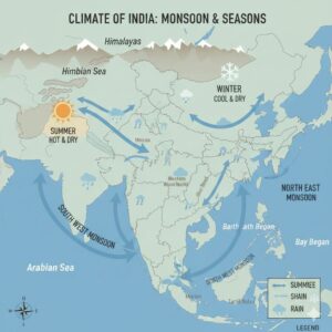
Question 2.
Explain the South West Monsoon season with the help of a map.
Answer:
The South West Monsoon season extends from June to September and is also called the Advancing Monsoon Season. During this period, India receives more than 75% of its annual rainfall.
Due to high temperature over the Indian landmass, a low-pressure area is formed, while high pressure exists over the Indian Ocean. Moisture-laden winds blow from the ocean towards land as South West Monsoon winds.
These winds split into two branches:
- Arabian Sea branch, which brings heavy rainfall to the Western Ghats and Malabar Coast.
- Bay of Bengal branch, which brings rainfall to the eastern coast and north-eastern regions.
The merging of both branches causes very heavy rainfall in areas like Mawsynram and Cherrapunji. This season is very important for Kharif crops and the Indian economy.
Question 3.
Briefly explain the characteristic features of Winter and Summer seasons.
Answer:
The Winter Season (December to February):
The winter season is also known as the cold weather season. During this season, the direct rays of the Sun fall on the Tropic of Capricorn, and India receives oblique sun rays. Temperature decreases from south to north, and regions north of the Tropic of Cancer experience lower temperatures than the southern regions. The average temperature is around 18°C, while in the northern plains it falls below 5°C. January is the coldest month. Jammu and Kashmir, Punjab, Haryana, Uttar Pradesh and parts of Bihar experience severe cold and snowfall. Rainfall is very low, about 2%, but it is useful for Rabi crops in North India.
The Summer Season (March to May):
The summer season is also called the hot weather season and lasts from March to May. During this period, the Sun’s rays shift from the Tropic of Capricorn towards the Equator, causing a gradual increase in temperature from south to north. Southern states like Tamil Nadu, Andhra Pradesh, Karnataka and Kerala experience high temperatures. Some parts of Andhra Pradesh and Karnataka record temperatures above 40°C, while Sri Ganganagar in Rajasthan records the highest temperature of above 52°C. The average temperature of the country is around 24°C. Some regions receive convectional rainfall, and about 10% of the annual rainfall occurs during this season.
Question 4.
Give details of North East Monsoon season.
Answer:
The North East Monsoon season is also called the Retreating Monsoon Season. It begins in the middle of September and extends up to the middle of December. On September 23rd, the direct rays of the Sun fall on the Equator, resulting in changes in temperature and pressure over land and water bodies.
During this period, high pressure develops over the northern part of the Bay of Bengal, while relatively low pressure exists over the Indian Ocean. Due to this pressure difference, winds blow from the north-eastern part of India towards the south-western region. These winds blow along the eastern coast of India and the Bay of Bengal and bring rainfall to the Coromandel Coast, especially Tamil Nadu.
Due to pressure variations, cyclones and anti-cyclones originate in the Bay of Bengal during this season. These cyclones cause heavy rainfall and damage along the eastern coast. The coastal areas of Tamil Nadu, Andhra Pradesh, Odisha and West Bengal are frequently affected. Some important cyclones recorded in recent years are Bola, Nargis, Nisha, Laila, Jal and Neelam.
Question 5.
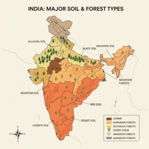
What is Soil? Explain the major types of soils.
Answer:
Soil is the minute or finer rock particles found on the surface of the Earth. It is formed naturally due to the weathering of rocks under the influence of climate. Soil is an important natural resource as it provides nutrients and water to plants.
The major types of soils found in India are:
- Alluvial Soil
Alluvial soil is formed by the depositional work of rivers and is mainly found in flood plains and river deltas. It covers the largest geographical area in India and is widely distributed in the plains of the Ganga, Brahmaputra and Indus rivers. Uttar Pradesh has the largest area under alluvial soil. It is also found in the deltas of east-flowing rivers.
Alluvial soil is of two types:
- Bhangar: Old alluvium, coarse and pebble-like in nature, found at higher levels of the plains.
- Khadar: New alluvium, fine-grained, found in low-lying flood plains and very fertile.
- Black Soil
Black soil is mainly found in the Peninsular Plateau. It is also known as Cotton soil or Regur soil and is derived from weathered basalt rocks. This soil has high water-holding capacity and becomes hard when dry. It is light-black to dark-black in colour.
Black soil is widely found in Maharashtra, Gujarat, Madhya Pradesh, Karnataka, Andhra Pradesh and Tamil Nadu. It is suitable for crops like cotton, sugarcane, tobacco, pulses, millets and citrus fruits.
- Red Soil
Red soil is formed from weathered granite rocks and is red in colour due to the presence of iron (ferrous content). It covers the second largest area in India and is widely found in the Peninsular region. Tamil Nadu has the largest distribution of red soil.
Major crops grown in this soil are rice, ragi, jowar, groundnut, tobacco and millets.
- Laterite Soil
Laterite soil is found in hot and humid tropical regions. It is formed due to the intense weathering of rocks in hilly and mountainous regions. This soil is mainly found in the Western Ghats, parts of Eastern Ghats and North-Eastern hills.
It is suitable for plantation crops like tea, coffee, rubber and cashew nut.
- Desert Soil
Desert soil, also called arid soil, is found in the desert and semi-desert regions of western and north-western India. It has low water-holding capacity and less humus content, making it generally unsuitable for cultivation.
This soil is found in Rajasthan, parts of Gujarat and Haryana. With irrigation facilities, crops like bajra, pulses and guar are cultivated.
- Mountain Soil
Mountain or forest soil is found on the slopes and valleys of the Himalayan region. It is mainly seen in Jammu and Kashmir, Himachal Pradesh and Uttarakhand.
Crops like tea, almond and saffron are cultivated in this soil.
Question 6.
Explain soil erosion and conservation of soil.
Answer:
Soil erosion is the process of removal or wearing away of the top fertile layer of soil by various natural agents and human activities. The main natural agents of soil erosion are rainfall, wind, waves and high temperature. Human activities such as deforestation, overgrazing, shifting cultivation, improper and unscientific agricultural practices also accelerate soil erosion. In hilly regions, heavy rainfall and temperature cause severe soil erosion, while in coastal areas sea waves and in desert regions strong winds are the dominant factors.
Soil conservation refers to the prevention of soil erosion and the protection and maintenance of soil fertility. The important measures of soil conservation are:
- Afforestation
- Control of overgrazing
- Contour ploughing
- Terrace farming
- Erection of bunds
- Construction of check dams
- Crop rotation
- Strip farming
- Mulching
- Literacy and awareness programmes on soil conservation
Question 6.
Explain soil erosion and conservation of soil.
Answer:
Soil erosion is the process of removal or wearing away of the top fertile layer of soil by various natural agents and human activities. The main natural agents of soil erosion are rainfall, wind, waves and high temperature. Human activities such as deforestation, overgrazing, shifting cultivation, improper and unscientific agricultural practices also accelerate soil erosion. In hilly regions, heavy rainfall and temperature cause severe soil erosion, while in coastal areas sea waves and in desert regions strong winds are the dominant factors.
Soil conservation refers to the prevention of soil erosion and the protection and maintenance of soil fertility. The important measures of soil conservation are:
Important measures of soil conservation are:
- Afforestation
- Control of overgrazing
- Contour ploughing
- Terrace farming
- Construction of bunds
- Building check dams
- Crop rotation
- Strip farming
- Mulching
- Awareness and education programmes on soil conservation
Question 7.
Describe the major types of forests in India.
Answer:
India has a wide variety of forests due to diverse climatic and geographical conditions.
The Peninsular region accounts for about 57% of the total forest area.
Based on geo-climatic conditions, forests are classified as follows:
a) Evergreen Forests
These forests are found in regions of heavy rainfall and high temperature.
They remain green throughout the year as trees shed leaves in different seasons.
Important trees: Rosewood, ebony, mahogany, bamboo, cane, gurjan, chaplash.
Regions: Western Ghats, North-East India, Andaman and Nicobar Islands, Assam and Himalayan foothills.
b) Deciduous Forests
These forests shed their leaves during a particular season and cover a large part of India.
They are rich in wildlife such as tiger, elephant, bison and gaur.
They are of two types:
(i) Moist Deciduous Forests
- Rainfall: 100–200 cm
- Temperature: 25°C–30°C
- Regions: Eastern slopes of Western Ghats, Chota Nagpur Plateau, Siwaliks
(ii) Dry Deciduous Forests
- Rainfall: 50–150 cm
- Temperature: 25°C–30°C
- Important trees: Sal, acacia, bamboo
- Regions: Central Deccan Plateau, Rajasthan, Punjab, Haryana, Uttar Pradesh and Madhya Pradesh
c) Mountain Forests
These forests are found in the Himalayan region.
Trees are conical in shape with needle-like leaves.
Important trees: Oak, pine, fir, spruce, deodar, juniper
They provide softwood used in making boats, packing materials and sports goods.
d) Desert Forests
Found in areas of very low rainfall.
Vegetation includes thorny bushes, shrubs, acacia, babul and cactus.
Regions: Rajasthan, Gujarat, Punjab and Haryana
Plants have long roots and thick stems to store water.
e) Mangrove Forests
Found in river deltas and coastal regions.
The Ganga delta mangroves are known as Sunderbans.
Regions: Deltas of Ganga, Mahanadi, Godavari, Krishna, and coastal areas of Gujarat
They protect coastal regions from tidal waves and erosion.
Question 8.
Briefly explain the importance of forests.
Answer:
Forests are one of the most important natural resources.
Importance of forests:
- Supply oxygen, food, fodder and fuel
- Help in causing rainfall
- Control soil erosion and desertification
- Provide timber, bamboo, resin, gum, lac and firewood
- Supply medicinal plants like neem, tulsi and brahmi
- Provide habitat for wildlife
- Control floods and protect against droughts
- Act as wind breakers and protect crops
- Maintain soil fertility through humus
- Provide raw materials for paper, plywood and match industries
Question 9.
Explain the important measures of conservation of forest.
Answer:
Forest conservation involves proper use, protection and management of forests.
Important measures:
- Avoid careless felling, overgrazing and shifting cultivation
- Promote afforestation and reforestation
- Control forest fires, pests and diseases scientifically
- Prevent encroachment and punish offenders
- Encourage programmes like Vanamahotsava and Social Forestry
- Compensate industrial and mining activities with tree planting
- Develop green belts in urban areas
- Plant trees along roads, railways, canals and river banks
- Reduce dependence on fuel wood
- Create public awareness through media and education
Question 10.
What are Biosphere Reserves? Mention important biosphere reserves of India.
Answer:
A Biosphere Reserve is a protected area meant for the conservation of biodiversity, ecosystems and sustainable development.
The surrounding areas are used for research, education and experimentation.
The UNESCO Man and the Biosphere (MAB) Programme was started in 1971.
Objectives of Biosphere Reserves:
- Conservation of biodiversity and ecosystems
- Linking environment with development
- Research, monitoring and education
Important Biosphere Reserves of India:
Sl.No | Biosphere Reserve | State | Established |
1 | Nilgiri | TN, Kerala, Karnataka | 2000 |
2 | Gulf of Mannar | Tamil Nadu | 2001 |
3 | Sundarbans | West Bengal | 2001 |
4 | Nanda Devi | Uttarakhand | 2004 |
5 | Nokrek | Meghalaya | 2009 |
6 | Pachmarhi | Madhya Pradesh | 2009 |
7 | Simlipal | Odisha | 2008 |
8 | Achanakmar–Amarkantak | Chhattisgarh, Jharkhand | 2012 |
Additional Questions and Answer:
I. One Mark Questions & Answers
Question 1.
What is soil erosion?
Answer:
Removal of fertile topsoil by natural and human factors is called soil erosion.
Question 2.
Name any one natural agent of soil erosion.
Answer:
Rainfall.
Question 3.
Mention any one human cause of soil erosion.
Answer:
Deforestation.
Question 4.
What is soil conservation?
Answer:
Protection and maintenance of soil fertility is called soil conservation.
Question 5.
Name any one method of soil conservation.
Answer:
Contour ploughing.
Question 6.
Which region of India has the largest forest cover?
Answer:
The Peninsular region.
Question 7.
What are evergreen forests?
Answer:
Forests that remain green throughout the year are called evergreen forests.
Question 8.
Name any one tree found in evergreen forests.
Answer:
Rosewood.
Question 9.
What are deciduous forests?
Answer:
Forests that shed their leaves seasonally are called deciduous forests.
Question 10.
Name any one wildlife found in deciduous forests.
Answer:
Tiger.
Question 11.
What are mangrove forests?
Answer:
Forests found in coastal and delta regions are called mangrove forests.
Question 12.
What is the Sunderbans famous for?
Answer:
Mangrove forests.
Question 13.
What are desert forests?
Answer:
Forests found in low rainfall areas with thorny vegetation.
II. Two Mark Questions & Answers
Question 1.
Mention any two causes of soil erosion.
Answer:
- Heavy rainfall
- Deforestation
Question 2.
State any two measures of soil conservation.
Answer:
- Afforestation
- Terrace farming
Question 3.
Give two characteristics of evergreen forests.
Answer:
- Found in heavy rainfall regions
- Remain green throughout the year
Question 4.
Mention any two areas where evergreen forests are found in India.
Answer:
- Western Ghats
- Andaman and Nicobar Islands
Question 5.
State two features of deciduous forests.
Answer:
- Trees shed leaves seasonally
- Support rich wildlife
Question 6.
Mention two differences between moist and dry deciduous forests.
Answer:
- Moist deciduous forests receive higher rainfall
- Dry deciduous forests receive lower rainfall
Question 7.
Write any two characteristics of mountain forests.
Answer:
- Found in Himalayan regions
- Trees have needle-like leaves
Question 8.
Mention two characteristics of desert forests.
Answer:
- Found in low rainfall areas
- Vegetation has long roots and thorny leaves
Question 9.
State two features of mangrove forests.
Answer:
- Found in delta and coastal regions
- Protect coasts from erosion
CLICK HERE TO DOWNLOAD Climate, Soil and Forest PDF
CLICK HERE TO WATCH Climate, Soil and Forest VIDEO
Climate, Soil and Forests – 1st PUC Geography
This content is prepared strictly according to the Karnataka State Board syllabus to help students understand climate seasons, soil types, forest resources, conservation methods, and biosphere reserves in an easy and exam-oriented manner.
All notes, questions and answers are designed for board exam preparation and quick revision.